Category:Eglise (Renan)
Jump to navigation
Jump to search
| Object location | | View all coordinates using: OpenStreetMap |
|---|
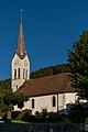
church building in Renan in the canton of Bern, Switzerland  | |||||
| Upload media | |||||
| Instance of | |||||
|---|---|---|---|---|---|
| Part of | |||||
| Location | Renan, Bernese Jura administrative district, Bernese Jura administrative region, Bern, Switzerland | ||||
| Street address |
| ||||
| Heritage designation | |||||
| Inception |
| ||||
 | |||||
Media in category "Eglise (Renan)"
The following 3 files are in this category, out of 3 total.
-
 2018-Renan-Eglise-1.jpg 1,280 × 1,920; 1.65 MB
-
 2018-Renan-Eglise-2.jpg 1,280 × 1,920; 2.17 MB
-
 Reformierte Kirche, Renan BE 20220727-jag9889.jpg 3,456 × 4,608; 9.05 MB

