Category:Eglise St-Romain avec clocher et voisinage (Ayent)
Jump to navigation
Jump to search
| Object location | | View all coordinates using: OpenStreetMap |
|---|
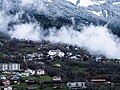
church building in Ayent in the canton of Valais, Switzerland  | |||||
| Upload media | |||||
| Instance of | |||||
|---|---|---|---|---|---|
| Part of | |||||
| Location |
| ||||
| Street address |
| ||||
| Heritage designation | |||||
 | |||||
Media in category "Eglise St-Romain avec clocher et voisinage (Ayent)"
The following 3 files are in this category, out of 3 total.
-
 Saint-Romain - Ayent.jpg 5,533 × 4,150; 16.45 MB
-
 Église de Saint-Romain - Ayent.jpg 4,987 × 3,740; 9.57 MB
-
 Église Saint-Romain d'Ayent (Suisse).jpg 2,988 × 5,312; 3.28 MB

.jpg)