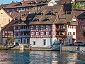
Category:Ehemalige Gerberei/Badstube (Diessenhofen)
Jump to navigation
Jump to search
| Object location | | View all coordinates using: OpenStreetMap |
|---|
|
This is a category about a cultural property of regional significance in Switzerland with KGS number 13666
|
building in Diessenhofen, Switzerland  | |||||
| Upload media | |||||
| Instance of | |||||
|---|---|---|---|---|---|
| Part of | |||||
| Location |
| ||||
| Street address |
| ||||
| Heritage designation |
| ||||
 | |||||
Media in category "Ehemalige Gerberei/Badstube (Diessenhofen)"
The following 3 files are in this category, out of 3 total.
-
 Fachwerkhäuser an der Rheinhalde in Diessenhofen TG.jpg 4,000 × 3,000; 9.12 MB
-
 Wohnhaus Badstube Gerberei Diessenhofen P1030190.jpg 5,184 × 3,888; 9.67 MB
-
 Wohnhaus Badstube Gerberei Diessenhofen P1030192.jpg 5,184 × 3,888; 10.47 MB

