Category:Ehemalige Schule Wallenrod DE HE 66770
Jump to navigation
Jump to search
| Object location | | View all coordinates using: OpenStreetMap |
|---|
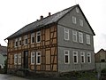
Cultural heritage monument in Wallenrod, Hesse, Germany  | |||||
| Upload media | |||||
| Instance of | |||||
|---|---|---|---|---|---|
| Location | Wallenrod, Lauterbach, Vogelsbergkreis, Giessen Government Region, Hesse, Germany | ||||
| Street address |
| ||||
| Heritage designation | |||||
 | |||||
This is the category of the Hessian Kulturdenkmal (cultural monument) with the ID 66770 (Wikidata)
|
Media in category "Ehemalige Schule Wallenrod DE HE 66770"
The following 2 files are in this category, out of 2 total.
-
 66770 Helmut-Caspar-Weg 3 Wallenrod.jpg 2,682 × 2,012; 1.19 MB
-
 DE HE 66770 2.jpg 3,072 × 2,304; 1.92 MB
