Category:Eindstraat, Breda
Jump to navigation
Jump to search
| Camera location | | View all coordinates using: OpenStreetMap |
|---|
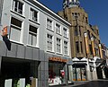
Nederlands: Afbeeldingen van de winkelstraat de Eindstraat, Breda in Breda Centrum van Breda in de provincie Noord-Brabant in het zuiden van Nederland. De Eindstraat is een verlengde van de Ginnekenstraat en gaat daarna verder als de Karrestraat. Ze vormen samen de belangrijkste winkelstraten van het centrum van Breda met onder meer het overdekte winkelcentrum De Barones met diverse nieuwe grote winkels.
Nabij de Grote Kerk Breda en de Grote Markt Breda. (bron [1]).
street in Breda, the Netherlands | |||||
| Upload media | |||||
| Instance of | |||||
|---|---|---|---|---|---|
| Location | Breda, North Brabant, Netherlands | ||||
| Street address |
| ||||
 | |||||
Media in category "Eindstraat, Breda"
The following 27 files are in this category, out of 27 total.
-
 0950newEindstraat.jpg 1,280 × 1,600; 461 KB
-
 2010-04-25-breda-by-RalfR-34.jpg 3,008 × 2,000; 2.1 MB
-
 Costes Women P1660884 copy.jpg 3,409 × 2,054; 1.51 MB
-
 Costes Women P1660885 copy.jpg 3,132 × 2,027; 1.26 MB
-
 Eindstraat Breda Centrum DSCF8399.JPG 2,112 × 2,816; 2.61 MB
-
 Eindstraat DSCF8395.JPG 2,816 × 2,112; 2.69 MB
-
 Eindstraat, Breda P1030232 copy.jpg 2,448 × 3,264; 4.69 MB
-
 Eindstraat, Breda P1340033.jpg 4,000 × 2,672; 5.73 MB
-
 Eindstraat, Breda P1600069.jpg 4,000 × 2,672; 5.33 MB
-
 Eindstraat, Breda P1600071.jpg 4,000 × 2,672; 5.05 MB
-
 Eindstraat, Breda P1600072.jpg 4,000 × 2,672; 5.62 MB
-
 Eindstraat, Breda P1660886.jpg 4,000 × 3,000; 6.09 MB
-
 Eindstraat, Breda P1660887.jpg 4,000 × 3,000; 5.78 MB
-
 Eindstraat, Breda P1660888.jpg 3,000 × 4,000; 5.82 MB
-
 Eindstraat, Breda P1660889 copy.jpg 3,711 × 3,000; 1.83 MB
-
 Eindstraat, Breda P1660893.jpg 4,000 × 3,000; 6.08 MB
-
 Gevel Eindstraat Breda DSCF8778.JPG 2,816 × 2,112; 2.73 MB
-
 Ginnekenstraat Breda DSCF1713.JPG 2,816 × 2,112; 2.68 MB
-
 Hoek Eindstraat, Breda DSCF5730.jpg 1,864 × 2,816; 2.49 MB
-
 Hoek Eindstraat, Breda P1340032.jpg 4,000 × 2,672; 5.59 MB
-
 Hoek Houtmarkt Eindstraat, Breda DSCF0560.jpg 2,048 × 1,536; 1.56 MB
-
 Hoek Houtmarkt Eindstraat, Breda P1340031.jpg 2,672 × 4,000; 5.67 MB
-
 P1030233 copyGinnekenstraat.jpg 2,448 × 3,264; 5.02 MB
-
 P1030330 copyGinnekenstraat.jpg 2,448 × 3,264; 2.12 MB
-
 P1030332Ginnekenstraat.JPG 2,448 × 3,264; 3.63 MB
-
 Voorgevels - Breda - 20041004 - RCE.jpg 817 × 1,200; 212 KB
-
 Winkels Ginnekenstraat Breda DSCF2017.jpg 2,048 × 1,536; 1.56 MB


