Category:Eisenbahnbrücke 1935 (bei der Cementfabrik, Liesberg)
Jump to navigation
Jump to search
| Object location | | View all coordinates using: OpenStreetMap |
|---|
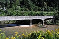
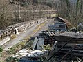
concrete bridge in Liesberg in the canton of Basel-Landschaft, Switzerland   | |||||
| Upload media | |||||
| Instance of | |||||
|---|---|---|---|---|---|
| Part of | |||||
| Location | Liesberg, Laufen District, Basel-Landschaft, Switzerland | ||||
| Street address |
| ||||
| Inception |
| ||||
 | |||||
Media in category "Eisenbahnbrücke 1935 (bei der Cementfabrik, Liesberg)"
The following 9 files are in this category, out of 9 total.
-
 Birsbruecke bei Liesberg 01 10.jpg 1,575 × 1,049; 1,023 KB
-
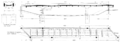 Birsbruecke bei Liesberg 01 11.png 2,588 × 899; 375 KB
-
 Birsbruecke bei Liesberg 02 10.jpg 1,575 × 1,049; 1.24 MB
-
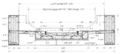 Birsbruecke bei Liesberg 02 11.png 1,232 × 558; 194 KB
-
 Birsbruecke bei Liesberg 03 10.jpg 1,575 × 1,049; 1.15 MB
-
 Birsbruecke bei Liesberg 04 10.jpg 1,575 × 1,049; 1.14 MB
-
 Birsbruecke bei Liesberg 05 10.jpg 1,575 × 1,049; 1.22 MB
-
 Birsbruecke bei Liesberg 06 10.jpg 1,575 × 1,049; 1.1 MB
-
 Stillgelegte Eisenbahn-Brücke über die Birs, Liesberg BL 20190402-jag9889.jpg 4,608 × 3,456; 11.47 MB


