Category:Election maps of Aberdeenshire
Jump to navigation
Jump to search
Council areas (municipalities) of Scotland: Aberdeen · Aberdeenshire · Angus · Dundee · East Lothian · East Renfrewshire · Edinburgh · Fife · Glasgow · North Lanarkshire · Outer Hebrides · Orkney Islands · Shetland Islands · West Lothian
Media in category "Election maps of Aberdeenshire"
The following 9 files are in this category, out of 9 total.
-
 2007 Aberdeenshire Council Election Results Map.svg 1,500 × 1,253; 1.2 MB
-
 2012 Aberdeenshire Council Election Results Map.svg 1,500 × 1,253; 1.2 MB
-
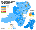 2017 Aberdeenshire Council Election Results Map.svg 1,500 × 1,253; 1.29 MB
-
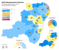 2022 Aberdeenshire Council Election Results Map.svg 1,500 × 1,253; 1.3 MB
-
 Aberdeenshire Council election 2003.svg 735 × 632; 1.16 MB
-
 Aberdeenshire Council election 2007.svg 1,425 × 1,253; 1.57 MB
-
 Aberdeenshire Council election 2012.svg 1,425 × 1,253; 1.58 MB
-
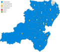 Aberdeenshire Council election 2017.svg 1,488 × 1,279; 142 KB
-
 Aberdeenshire Council results 2017.svg 4,055 × 2,476; 155 KB


