Category:Ellestraat 50, Elburg
Jump to navigation
Jump to search
| Object location | | View all coordinates using: OpenStreetMap |
|---|
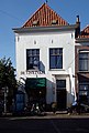
building in Elburg, Netherlands  | |||||
| Upload media | |||||
| Instance of | |||||
|---|---|---|---|---|---|
| Location | Elburg, Gelderland, Netherlands | ||||
| Street address |
| ||||
| Located on street |
| ||||
| Heritage designation |
| ||||
 | |||||
|
This is a category about rijksmonument number 14743
|
| Address |
|
Media in category "Ellestraat 50, Elburg"
The following 7 files are in this category, out of 7 total.
-
 Elburg - Ellestraat 50 RM14743.JPG 2,868 × 4,266; 2.22 MB
-
 Elburg - Westerwal - View North on Ellestraat.jpg 1,600 × 1,071; 346 KB
-
 Elburg, Netherlands - panoramio (54).jpg 4,896 × 3,264; 2.06 MB
-

-

-
 Overzicht - Elburg - 20068964 - RCE.jpg 819 × 1,200; 210 KB
-
 Voorgevels - Elburg - 20068963 - RCE.jpg 821 × 1,200; 225 KB

.jpg)


