Category:English-language maps of Australia
Jump to navigation
Jump to search
Subcategories
This category has the following 2 subcategories, out of 2 total.
E
- ECHO Daily Maps of Australia (21 F)
Media in category "English-language maps of Australia"
The following 26 files are in this category, out of 26 total.
-
 1989 Newcastle earthquake ShakeMap.svg 694 × 840; 1.17 MB
-
 1cavg7 201702 Australia.png 3,000 × 2,400; 116 KB
-
 2006decileanomaly - new.gif 680 × 467; 70 KB
-
 2009decileanomaly - new.gif 680 × 467; 68 KB
-
 2010decileanomaly.gif 680 × 467; 64 KB
-
 Aaron Arrowsmith, New Holland (FL27963653 2518620).jpg 6,378 × 5,315; 39.74 MB
-
 An atlas of commercial geography (1913) (14594767000).jpg 2,880 × 2,412; 1.63 MB
-
 As-map.png 329 × 353; 21 KB
-
 Australia - btv1b53065220c.jpg 10,912 × 8,496; 9.16 MB
-
 Australia - btv1b531954155.jpg 10,668 × 8,330; 13.27 MB
-
 Australia OCHA map.jpg 494 × 492; 134 KB
-
 Australian external territories.png 644 × 376; 14 KB
-
 Australian Extremities.png 2,190 × 1,652; 156 KB
-
 Australian Heatwave 2017 Satellite Imagery.png 720 × 598; 310 KB
-
 Australie. - Map of Australia, constructed for the use of schools - btv1b53023047n.jpg 9,600 × 7,963; 8.35 MB
-
 Beach towel, II (8600327864).jpg 900 × 1,200; 591 KB
-
 Deserts in Australia en.png 1,500 × 1,479; 2.11 MB
-
 Map of British Australia.jpg 3,552 × 2,927; 2.36 MB
-
-
-

-
 Map of Western Australia - btv1b53060414s.jpg 7,518 × 10,622; 13.02 MB
-
 PAT - Australia.gif 950 × 920; 147 KB
-

-
 Stanford's general map of Australia - btv1b53063390z.jpg 10,944 × 8,328; 11.63 MB
-
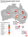 Top 3 languages taught in Australia schools by state or territory.png 754 × 982; 172 KB


.jpg)
_(14594767000).jpg)


.jpg)


..._-_btv1b53025345k.jpg)

