Category:English-language maps of Ukraine
Jump to navigation
Jump to search
Subcategories
This category has the following 4 subcategories, out of 4 total.
Media in category "English-language maps of Ukraine"
The following 67 files are in this category, out of 67 total.
-
 1996 Ukraine Oil and Gas (30849141416).jpg 2,240 × 2,519; 3.63 MB
-
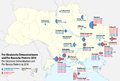
 2006 Ukrainian parliamentary election.svg 740 × 655; 3.6 MB
-
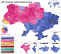 2007 Ukrainian parliamentary election.svg 740 × 655; 3.61 MB
-
 2012 Ukrainian parliamentary election - Constituency results.svg 3,499 × 3,100; 703 KB
-
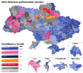
 2012 Ukrainian parliamentary election - List results.svg 3,500 × 3,100; 657 KB
-
 2014 pro-Russian unrest in Ukraine.svg 1,547 × 1,041; 786 KB
-
 2014 Ukrainian parliamentary election - Constituency results.svg 3,500 × 3,100; 729 KB
-
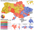 2014 Ukrainian parliamentary election - List results.svg 3,500 × 3,100; 751 KB
-
 2019 Ukrainian presidential election, round 1.svg 512 × 366; 389 KB
-
 2019 Ukrainian presidential election, round 2.svg 512 × 366; 201 KB
-
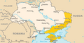
 2022 Russian Invasion of Ukraine Force Dispositions (February 24 2022).svg 1,546 × 1,150; 2.31 MB
-
 20220401 Ukraine.png 1,625 × 1,125; 867 KB
-
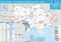 202204513 Ukraine Moldova ECHO-funded(1).pdf 1,625 × 1,125; 523 KB
-
 202204513 Ukraine Moldova ECHO-funded(1).png 3,250 × 2,250; 2.5 MB
-
 20231212 Ukraine Moldova ECHO funded hum assistance.png 3,250 × 2,250; 3.06 MB
-
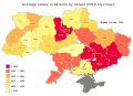
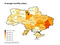 Average monthly salary in Ukraine, FY2013.jpg 1,771 × 1,328; 646 KB
-
 COVID-19 Outbreak Cases in Ukraine 2020-03-20.svg 1,547 × 1,041; 229 KB
-
 COVID-19 Outbreak Cases in Ukraine 2020-03-24.svg 1,547 × 1,041; 232 KB
-
 COVID-19 Outbreak Cases in Ukraine 2020-03-25.svg 1,547 × 1,041; 233 KB
-
 COVID-19 Outbreak Cases in Ukraine 2020-03-26.svg 1,547 × 1,041; 233 KB
-
 COVID-19 Outbreak Cases in Ukraine 2020-03-28.svg 1,547 × 1,041; 235 KB
-
 COVID-19 Outbreak Cases in Ukraine 2020-03-31.svg 1,547 × 1,041; 235 KB
-
 Dnipro-OSMMap.svg 512 × 324; 3.46 MB
-
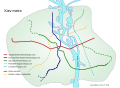 Kiev metro map en ru.svg 800 × 582; 74 KB
-
 Koppen-Geiger Map UKR future.svg 1,816 × 850; 1.14 MB
-
 Koppen-Geiger Map UKR present.svg 1,816 × 850; 1.1 MB
-
 Kyiv map (en).svg 658 × 640; 86 KB
-
 Left-Bank Ukraine.png 632 × 322; 55 KB
-
 Map of Ukraine en.svg 602 × 448; 1.28 MB
-
 Map of Ukraine political enwiki.png 1,417 × 990; 310 KB
-
 Map of Ukraine with Cities.png 4,844 × 3,255; 2.72 MB
-
 Map of Ukraine.gif 998 × 1,038; 261 KB
-
 Map pro-Ukrainean and pro-Russian protests in the Ukraine 2014.png 2,147 × 1,442; 477 KB
-
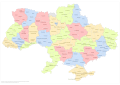 Raions of Ukraine (after Oct. 2020) EN.svg 1,488 × 1,052; 2.65 MB
-
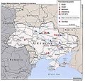
 RU and UA forces, 2014.04 (April) - EN 01.jpg 1,785 × 1,260; 620 KB
-
 Russian invasion of Ukraine 2022 new.svg 2,199 × 1,478; 3.32 MB
-
 Russian invasion Ukraine testcolors.jpg 2,867 × 1,920; 3.24 MB
-
 Solar Map of Ukraine.png 1,000 × 784; 566 KB
-
 Street map of central Kiev. LOC 79693429.jpg 12,912 × 10,463; 9.9 MB
-
 Topographic map of Ukraine (with borders and towns).svg 1,449 × 959; 7.28 MB
-
 Town plan, Odessa. LOC 82693964.jpg 8,918 × 13,778; 12.37 MB
-
 Ukr elections 2014 multimandate okruhs.png 817 × 570; 323 KB
-
 Ukraine - DPLA - 85103723f77165333c5620a530a8ccf4.jpg 2,560 × 3,284; 4.56 MB
-
 Ukraine - DPLA - 97ebf91dea23fe9ee238ff175d6d14e8.jpg 2,538 × 3,272; 4.39 MB
-
 Ukraine - DPLA - dee3c987010d47e6193db6bc7578c8ee.jpg 2,562 × 3,278; 4.58 MB
-
 Ukraine - Location Map (2010) - UKR - UNOCHA.svg 254 × 254; 1.03 MB
-
 Ukraine Administrative Divisions - DPLA - 9573fb782c9870239a48931ab758a2ca.jpg 2,560 × 3,282; 4.46 MB
-
 Ukraine administrative divisions. LOC 2005626466.jpg 2,539 × 2,962; 594 KB
-
 Ukraine arms assembly.jpg 1,012 × 974; 234 KB
-
 Ukraine Base Map.png 1,104 × 697; 477 KB
-
 Ukraine CIA map.gif 635 × 324; 32 KB
-
 Ukraine DNI Solar-resource-map GlobalSolarAtlas World-Bank-Esmap-Solargis.png 1,842 × 1,764; 1.49 MB
-
 Ukraine Energy Factsheet MAP.png 1,169 × 844; 180 KB
-
 Ukraine GHI Solar-resource-map GlobalSolarAtlas World-Bank-Esmap-Solargis.png 1,842 × 1,764; 1.47 MB
-
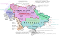 Ukraine Historical Borders.svg 988 × 605; 1.06 MB
-
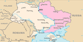
 Ukraine map (disputed territory).png 632 × 321; 61 KB
-
 Ukraine Map CIA 20201118.jpg 635 × 324; 56 KB
-
 Ukraine map of Köppen climate classification.svg 1,900 × 1,375; 146 KB
-
 Ukraine regions map.png 2,600 × 1,764; 1.48 MB
-
 Ukraine salary by region 2016.svg 550 × 400; 900 KB
-
 Ukraine. LOC 2005626463.jpg 2,522 × 2,869; 703 KB
-
 Ukraine. LOC 2005626464.jpg 2,539 × 3,080; 784 KB
-
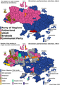 Ukrainian parliamentary election, 2012.png 3,453 × 4,850; 826 KB
-
 Ukrainian subdivisions by GRP 2018.png 6,000 × 3,614; 1.15 MB
-
 Ukrainians en.svg 1,000 × 640; 2.11 MB
-
 War in Ukraine (2022) en.png 2,560 × 1,796; 542 KB
-

.jpg)


.svg)

.png)


.svg)


_EN.svg)
_-_EN_01.jpg)


.svg)


_-_UKR_-_UNOCHA.svg)


.png)


_en.png)
