Category:Equirectangular projection
Jump to navigation
Jump to search
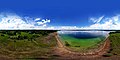
English: Equirectangular projection (also called the Marinus projection (from its inventor Marinus of Tyre), equidistant cylindrical projection, or la carte parallélogrammatique projection) is simple mapping geographic to rectangular coordinates, so it is the mostly used projection in computer graphics. This includes the special case of the plate carrée projection or geographic projection.
- (en) Equirectangular projection
- (de) Rektangularprojektion
- (simple) Equirectangular projection
English: This map-projection-related category exists in the following hierarchy:
- Category:Map projections
- Category:Maps by projection
- Category:Equirectangular projection – media related to the Equirectangular projection other than maps
- Category:Maps with Equirectangular projection (“Category:Equirectangular projections”) – maps made using the Equirectangular projection
A projection in which the horizontal coordinate is simply longitude, and the vertical coordinate is simply latitude, with no transformation or scaling applied. | |||||
| Upload media | |||||
| |||||
Subcategories
This category has the following 3 subcategories, out of 3 total.
3
E
P
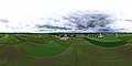
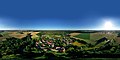
Media in category "Equirectangular projection"
The following 61 files are in this category, out of 61 total.
-
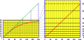
 Cyl proj scale 3examples.svg 410 × 270; 46 KB
-
 Battery Point Beach, Crecent City, California May 2023.jpg 18,746 × 9,373; 60.6 MB
-
 Battery Point Beach, Crecent City, California May 2023.png 18,746 × 9,373; 160.65 MB
-
 Central Mexico.png 691 × 492; 278 KB
-
 Chiemsee bei Seebruck Luftbild.jpg 24,000 × 12,000; 83.72 MB
-
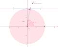
 Circle plane equirectangular.png 1,170 × 960; 139 KB
-
 Constellations, equirectangular plot.svg 512 × 256; 46 KB
-
 Ehrwald Panorama.jpg 16,000 × 8,000; 23.7 MB
-
 Equirectangular ceiling floor.jpg 1,045 × 633; 43 KB
-
 Equirectangular polar side view.gif 612 × 501; 154 KB
-
 Equirectangular screenshot ceiling.png 1,359 × 685; 338 KB
-
 Equirectangular screenshot floor.png 1,116 × 666; 148 KB
-
 Erdfunkstelle Raisting Luftbildpanorama.jpg 24,000 × 12,000; 51.45 MB
-
 Erdfunkstelle Raisting.jpg 20,000 × 10,000; 32.95 MB
-
 Floor sand for equirectangular.jpg 3,264 × 2,448; 4.6 MB
-
 Forggensee Panorama.jpg 16,000 × 8,000; 11.42 MB
-
 Fraueninsel Chiemsee Panorama.jpg 26,000 × 13,000; 65.82 MB
-
 Fraueninsel Chiemsee.jpg 24,000 × 12,000; 91.35 MB
-
 HD 15000 x 6500 Equirectangular Blank Political Map with Oceans Marked in Blue.png 15,000 × 6,500; 473 KB
-
 Hiouchi, California May 2023.jpg 18,758 × 9,379; 69.36 MB
-
 Hiouchi, California May 2023.png 18,758 × 9,379; 174.38 MB
-
 Hopfensee Panorama.jpg 16,000 × 8,000; 17.51 MB
-
 Horizontal angle of view for door meaure distance.jpg 2,296 × 4,080; 4 MB
-
 Horizontal angle of view meaure distance.jpg 2,296 × 4,080; 4 MB
-
 Horizontal angle of view.gif 588 × 444; 379 KB
-
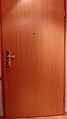 Horizontal angle of view.jpg 2,296 × 4,080; 4 MB
-
 Kade Riemsdijkweg NDSM-werf 3.jpg 5,520 × 3,860; 6.36 MB
-
 Kochelsee Panorama.jpg 16,000 × 8,000; 9.12 MB
-
 Luftbildpanorama Eschlbach.jpg 16,000 × 8,000; 13.19 MB
-
 Luftbildpanorama FFW Feldkirchen.jpg 16,000 × 8,000; 14.77 MB
-
 Luftbildpanorama Geisling.jpg 16,000 × 8,000; 15.58 MB
-
 Luftbildpanorama Hüttenkofen.jpg 16,000 × 8,000; 12.93 MB
-
 Luftbildpanorama Straubing am Hagen.jpg 16,000 × 8,000; 14.19 MB
-
 Luftbildpanorama Straubing Donau.jpg 16,000 × 8,000; 10.78 MB
-
 Luftbildpanorama Tunzenberg.jpg 16,000 × 8,000; 10.11 MB
-
 Mercator and straightened rhumb.png 978 × 471; 59 KB
-
 Mercator and straightened rhumb.svg 944 × 456; 124 KB
-
 PeterW zt inside equirectangular1303.797.jpg 8,192 × 4,096; 1.73 MB
-
 PeterW zt outside equirectangular2607.595.jpg 16,384 × 8,192; 1.51 MB
-
 Projection rectangular image4wikiversity.png 1,142 × 692; 116 KB
-
 River rhine spheric preview.png 1,615 × 903; 2.13 MB
-
 Schwangau Panorama.jpg 16,000 × 8,000; 14.56 MB
-
 Sky image for equirectangular projection.jpg 2,296 × 4,080; 4 MB
-
 SphericalStereo 01.jpg 8,192 × 8,192; 43.45 MB
-
 SphericalStereoDepth 01.png 8,192 × 8,192; 9.68 MB
-
 Starnberger See Panorama.jpg 16,000 × 8,000; 13.88 MB
-
 Tilted Earth Coastline Equirectangular.svg 2,398 × 1,347; 322 KB
-
 Tissot 02deg oblique.png 4,096 × 2,048; 1,015 KB
-
 Tissot 06deg oblique.png 4,096 × 2,048; 370 KB
-
 Tissot 10deg.png 4,096 × 2,048; 214 KB
-
 Tissot 15deg.png 4,096 × 2,048; 150 KB
-
 Tissot 2deg.png 4,096 × 2,048; 826 KB
-
 Tissot 30deg.png 4,096 × 2,048; 84 KB
-
 Tissot 45deg.png 4,096 × 2,048; 65 KB
-
 Tissot 6deg.png 4,096 × 2,048; 350 KB
-
 Triangle Vault 360 DEG HQ 10K OpenCL 20200522.png 10,000 × 5,000; 201.85 MB
-
 Triangle Vault 360 DEG HQ 5K OpenCL 20200522 8Bit.jpg 5,000 × 2,500; 15.97 MB
-
 Universal Transverse Mercator zones.svg 512 × 267; 535 KB
-
 World Elevation Map 8 bit (World Height map) (alterative version).png 21,600 × 10,800; 32.28 MB
-
 World elevation map.png 21,600 × 10,800; 71.79 MB
-
 World-airline-routemap-2009.png 2,048 × 1,025; 2.43 MB


_(alterative_version).png)

