Category:Espace naturel sensible de l'Étang de Montjoux
Jump to navigation
Jump to search
Français : Situé entre Meyrieux-les-étangs et Saint-Jean de Bournay, l'Espace naturel sensible de l’Étang de Montjoux est à une altitude de 400m, au nord-ouest du département de l’Isère et couvre une surface de 61,1 hectares.
English: Located between Meyrieux-les-étangs and Saint-Jean de Bournay, the Sensible Natural Area of Pond Montjoux is at an altitude of 400m, north-west of the department of Isère and covers an area of 61,1 hectares.
| Object location | | View all coordinates using: OpenStreetMap |
|---|
Media in category "Espace naturel sensible de l'Étang de Montjoux"
The following 39 files are in this category, out of 39 total.
-
 Abeille Salsifi 2.jpg 4,775 × 3,175; 9.34 MB
-
 Abeille Salsifi.jpg 5,245 × 3,374; 10.43 MB
-
 Aglais io - Aérodynamisme.jpg 2,554 × 2,554; 3.87 MB
-
 Aglais io - Paon 1.jpg 2,481 × 1,684; 2.36 MB
-
 Aglais io - Paon 2.jpg 2,736 × 1,816; 2.81 MB
-
 Aglais io - Paon 3.jpg 2,833 × 1,966; 3.34 MB
-
 Araschnia levana - Carte Géo 1.jpg 3,364 × 2,295; 4.53 MB
-
 Araschnia levana - Carte Géo 2.jpg 3,283 × 2,349; 5.6 MB
-
 Araschnia levana - Carte Géo 3.jpg 3,632 × 2,349; 5.66 MB
-
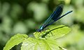
 Calopteryx 1.jpg 4,762 × 3,013; 8.21 MB
-
 Calopteryx 2.jpg 2,420 × 1,448; 1.95 MB
-
 Calopteryx 3.jpg 4,110 × 2,288; 4.72 MB
-
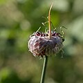
 Carpocoris Juvénile 1.jpg 2,207 × 1,456; 2.13 MB
-
 Carpocoris Juvénile 2.jpg 4,742 × 3,102; 10.12 MB
-
 Carpocoris Montjoux.jpg 4,199 × 2,898; 7.19 MB
-
 Citron Scabieuse.jpg 2,881 × 2,881; 4.91 MB
-
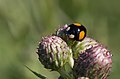
 Coccinelle Centaurée 1.jpg 4,497 × 2,952; 6.21 MB
-
 Coccinelle Centaurée 2.jpg 4,497 × 2,952; 6.88 MB
-
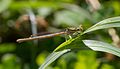
 Coenagrion Bleu Orange.jpg 4,584 × 2,889; 5.48 MB
-
 Coenagrion Orange.jpg 4,109 × 2,364; 6.4 MB
-
 Garlic Wild.jpg 3,195 × 3,195; 5.71 MB
-
 Goinfre Œdemere.jpg 3,180 × 2,081; 4.33 MB
-
 Leptophyes punctatissima - Sauterelle Ponctuée.jpg 4,894 × 3,464; 9.67 MB
-
 Luzerne Rose.jpg 3,648 × 3,648; 6.7 MB
-
 Luzerne Violette.jpg 3,648 × 5,472; 9.4 MB
-
 Maniola jurtina Menthe.jpg 4,948 × 3,147; 9.86 MB
-
 Paon Trompe.jpg 5,155 × 3,482; 9 MB
-
 Patineur 1.jpg 1,471 × 963; 702 KB
-
 Patineur 2.jpg 1,635 × 1,004; 1.12 MB
-
 Patineur 3.jpg 1,376 × 834; 618 KB
-
 Salsifi Envahi.jpg 5,472 × 3,648; 11.03 MB
-
 Syrphe 1.jpg 3,366 × 2,132; 3.83 MB
-
 Syrphe 2.jpg 3,456 × 2,304; 4.19 MB
-
 Syrphe Coquelicot 1.jpg 5,133 × 3,367; 10.07 MB
-
 Syrphe Coquelicot 2.jpg 3,389 × 2,064; 5.05 MB
-
 Téléphore 1.jpg 2,996 × 1,970; 3.55 MB
-
 Téléphore Balcon 2.jpg 3,576 × 2,380; 5.42 MB
-
 Téléphore Balcon.jpg 3,576 × 2,380; 5.79 MB
-
 Œdemere Scabieuse.jpg 4,082 × 2,691; 7.15 MB


