Category:Eulerhof (Düsseldorf)
Jump to navigation
Jump to search
| Object location | | View all coordinates using: OpenStreetMap |
|---|
| Upload media | |||||
| Instance of | |||||
|---|---|---|---|---|---|
| Location | Düsseldorf, Düsseldorf Government Region, North Rhine-Westphalia, Germany | ||||
| Heritage designation | |||||
 | |||||
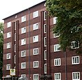
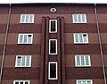
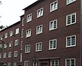
Deutsch: Eulerhof. Wohnanlage Dorotheenstraße 42–60, Degerstraße 47–55, Lindenstraße 185–197, Düsseldorf, Deutschland.
Media in category "Eulerhof (Düsseldorf)"
The following 44 files are in this category, out of 44 total.
-
 Düsseldorf - Eulerhof - .png 2,670 × 1,620; 7.38 MB
-
 Eulerhof, Degerstraße, Düsseldorf 1.jpg 2,854 × 2,772; 3.59 MB
-
 Eulerhof, Degerstraße, Düsseldorf 2.jpg 3,676 × 2,893; 4.06 MB
-
 Eulerhof, Degerstraße, Düsseldorf 3.jpg 2,760 × 3,664; 4.28 MB
-
 Eulerhof, Innenhof Durchfahrt zur Degerstraße.jpg 3,324 × 2,759; 4.34 MB
-
 Eulerhof, Lindenstraße, Düsseldorf.jpg 3,616 × 2,910; 4.06 MB
-
 Eulerhof, Toreinfahrten Degerstraße, Düsseldorf.jpg 3,864 × 2,867; 5.68 MB
-

-
 Wohnanlage Dorotheenstraße 42–60, Degerstraße 47–55, Lindenstraße 185–197, Düsseldorf (02).jpg 5,271 × 3,567; 11.22 MB
-
 Wohnanlage Dorotheenstraße 42–60, Degerstraße 47–55, Lindenstraße 185–197, Düsseldorf (04).jpg 5,232 × 3,537; 11.21 MB
-
 Wohnanlage Dorotheenstraße 42–60, Degerstraße 47–55, Lindenstraße 185–197, Düsseldorf (05).jpg 5,385 × 3,549; 11.54 MB
-

-
 Wohnanlage Dorotheenstraße 42–60, Degerstraße 47–55, Lindenstraße 185–197, Düsseldorf (09).jpg 5,337 × 3,612; 11.58 MB
-
 Wohnanlage Dorotheenstraße 42–60, Degerstraße 47–55, Lindenstraße 185–197, Düsseldorf (10).jpg 5,223 × 3,408; 10.74 MB
-
 Wohnanlage Dorotheenstraße 42–60, Degerstraße 47–55, Lindenstraße 185–197, Düsseldorf (11).jpg 5,385 × 3,513; 10.67 MB
-

-
 Wohnanlage Dorotheenstraße 42–60, Degerstraße 47–55, Lindenstraße 185–197, Düsseldorf (13).jpg 5,388 × 3,516; 11.24 MB
-

-

-

-

-

-

-

-

-

-
 Wohnanlage Dorotheenstraße 42–60, Degerstraße 47–55, Lindenstraße 185–197, Düsseldorf (23).jpg 5,190 × 3,437; 10.52 MB
-
 Wohnanlage Dorotheenstraße 42–60, Degerstraße 47–55, Lindenstraße 185–197, Düsseldorf (24).jpg 4,998 × 3,359; 10.15 MB
-
 Wohnanlage Dorotheenstraße 42–60, Degerstraße 47–55, Lindenstraße 185–197, Düsseldorf (25).jpg 4,983 × 3,309; 10.31 MB
-
 Wohnanlage Dorotheenstraße 42–60, Degerstraße 47–55, Lindenstraße 185–197, Düsseldorf (26).jpg 5,313 × 3,427; 11.38 MB
-
 Wohnanlage Dorotheenstraße 42–60, Degerstraße 47–55, Lindenstraße 185–197, Düsseldorf (27).jpg 4,700 × 3,575; 11.81 MB
-

-
 Wohnanlage Dorotheenstraße 42–60, Degerstraße 47–55, Lindenstraße 185–197, Düsseldorf (29).jpg 5,361 × 3,609; 12.65 MB
-
 Wohnanlage Dorotheenstraße 42–60, Degerstraße 47–55, Lindenstraße 185–197, Düsseldorf (30).jpg 5,397 × 3,615; 12.04 MB
-
 Wohnanlage Dorotheenstraße 42–60, Degerstraße 47–55, Lindenstraße 185–197, Düsseldorf (31).jpg 5,301 × 3,471; 11.81 MB
-

-

-
 Wohnanlage Dorotheenstraße 42–60, Degerstraße 47–55, Lindenstraße 185–197, Düsseldorf (35).jpg 4,809 × 3,426; 10.72 MB
-
 Wohnanlage Dorotheenstraße 42–60, Degerstraße 47–55, Lindenstraße 185–197, Düsseldorf (36).jpg 4,728 × 3,540; 10.66 MB
-

-
 Wohnanlage Dorotheenstraße 42–60, Degerstraße 47–55, Lindenstraße 185–197, Düsseldorf (38).jpg 4,803 × 3,421; 10.68 MB
-
 Wohnanlage Dorotheenstraße 42–60, Degerstraße 47–55, Lindenstraße 185–197, Düsseldorf (39).jpg 5,136 × 3,089; 11.37 MB
-
 Wohnanlage Dorotheenstraße 42–60, Degerstraße 47–55, Lindenstraße 185–197, Düsseldorf (40).jpg 4,890 × 3,558; 10.24 MB
-
 Wohnanlage Dorotheenstraße 42–60, Degerstraße 47–55, Lindenstraße 185–197, Düsseldorf (41).jpg 4,785 × 3,555; 10.29 MB


.jpg)
.jpg)
.jpg)
.jpg)
.jpg)
.jpg)
.jpg)
.jpg)
.jpg)
.jpg)
.jpg)
.jpg)
.jpg)
.jpg)
.jpg)
.jpg)
.jpg)
.jpg)
.jpg)
.jpg)
.jpg)
.jpg)
.jpg)
.jpg)
.jpg)
.jpg)
.jpg)
.jpg)
.jpg)
.jpg)
.jpg)
.jpg)
.jpg)
.jpg)
.jpg)
.jpg)
.jpg)
Categories:
- Buildings in Düsseldorf-Flingern Nord
- Cultural heritage monuments in Düsseldorf-Flingern Nord
- Brick Expressionism in Düsseldorf
- 1920s architecture in Düsseldorf
- Buildings by Hermann vom Endt
- Buildings by Walter vom Endt
- Buildings by Josef Kleesattel
- Degerstraße (Düsseldorf)
- Dorotheenstraße (Düsseldorf)
- Lindenstraße (Düsseldorf)