Category:Evangelisch-reformierte Kirche (Kirchweg 12, Buus)
Jump to navigation
Jump to search
| Object location | | View all coordinates using: OpenStreetMap |
|---|
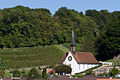
church building in Buus in the canton of Basel-Landschaft, Switzerland  | |||||
| Upload media | |||||
| Instance of | |||||
|---|---|---|---|---|---|
| Part of | |||||
| Location | Buus, Sissach District, Basel-Landschaft, Switzerland | ||||
| Street address |
| ||||
| Heritage designation | |||||
 | |||||
Media in category "Evangelisch-reformierte Kirche (Kirchweg 12, Buus)"
The following 2 files are in this category, out of 2 total.
-
 B-Buus-Ref-Kirche.jpg 1,200 × 1,800; 2.93 MB
-
 Buus-Kirche.jpg 1,200 × 800; 1.37 MB
