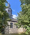
Category:Evangelische Kirche (Leuderode)
Jump to navigation
Jump to search
| Object location | | View all coordinates using: OpenStreetMap |
|---|
 | |||||
| Upload media | |||||
| Instance of | |||||
|---|---|---|---|---|---|
| Location | Leuderode, Frielendorf, Schwalm-Eder-Kreis, Kassel Government Region, Hesse, Germany | ||||
| Religion or worldview | |||||
 | |||||
Media in category "Evangelische Kirche (Leuderode)"
The following 3 files are in this category, out of 3 total.
-
 Evangelische Kirche Leuderode 01.jpg 3,106 × 3,577; 4.43 MB
-
 Evangelische Kirche Leuderode 02.jpg 3,754 × 2,816; 2.21 MB
-
 Evangelische Kirche Leuderode 03.jpg 2,678 × 3,504; 1.99 MB

