Category:Evangelische Kirche Battenfeld
Jump to navigation
Jump to search
| Object location | | View all coordinates using: OpenStreetMap |
|---|
This is the category of the Hessian Kulturdenkmal (cultural monument) with the ID 79094 (Wikidata)
|
church  | |||||
| Upload media | |||||
| Instance of | |||||
|---|---|---|---|---|---|
| Location | Allendorf (Eder), Waldeck-Frankenberg, Kassel Government Region, Hesse, Germany | ||||
| Heritage designation | |||||
 | |||||
Media in category "Evangelische Kirche Battenfeld"
The following 14 files are in this category, out of 14 total.
-
 Battenfeld - Kirche (0001).JPG 3,456 × 5,184; 5.65 MB
-
 Battenfeld - Kirche (0002).JPG 5,184 × 3,456; 5.97 MB
-
 Battenfeld - Kirche (0003).JPG 3,456 × 5,184; 8.71 MB
-
 Battenfeld - Kirche (0004).JPG 3,456 × 5,184; 5.58 MB
-
 Battenfeld - Kirche (0005).JPG 3,456 × 5,184; 5.09 MB
-
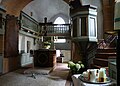
 Battenfeld - Kirche (innen) (0001).JPG 3,284 × 4,378; 6.98 MB
-
 Battenfeld - Kirche, Chor.jpg 3,922 × 2,798; 946 KB
-
 Battenfeld - Kirche, Innenraum.jpg 3,922 × 2,880; 1.17 MB
-
 Luthmer IV-017-Battenfeld Kirchturm.jpg 1,435 × 1,803; 948 KB
-
 Luthmer IV-018-Battenfeld Pfarrkirche Längsschnitt.jpg 1,849 × 726; 916 KB
-
 Luthmer IV-019-Battenfeld Pfarrkirche Grundriss.jpg 1,623 × 707; 623 KB
-
 Luthmer IV-020-Battenfeld Pfarrkirche Türbeschlag.jpg 953 × 2,182; 1.57 MB
-
 Luthmer IV-028-Emporen- und Unterzug-Stütze (Battenfeld Dautphe).jpg 1,839 × 965; 1.07 MB
-

.JPG)
.JPG)
.JPG)
.JPG)
.JPG)
_(0001).JPG)


.jpg)