Category:Evangelische Kirche Philippstein
Jump to navigation
Jump to search
| Object location | | View all coordinates using: OpenStreetMap |
|---|
Cultural heritage monument in Philippstein, Hesse, Germany  | |||||
| Upload media | |||||
| Instance of | |||||
|---|---|---|---|---|---|
| Location | Philippstein, Braunfels, Lahn-Dill-Kreis, Giessen Government Region, Hesse, Germany | ||||
| Street address |
| ||||
| Heritage designation | |||||
 | |||||
This is the category of the Hessian Kulturdenkmal (cultural monument) with the ID 44574 (Wikidata)
|
Media in category "Evangelische Kirche Philippstein"
The following 4 files are in this category, out of 4 total.
-
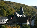 Evangelische Kirche Philippstein.jpg 2,560 × 1,920; 2.35 MB
-
 Philippstein, Evangelische Kirche.jpg 4,928 × 3,264; 7 MB
-
 Philippstein, Kirchstraße 2 (1).jpg 2,031 × 2,679; 3.29 MB
-
 Philippstein, Kirchstraße 2.jpg 3,024 × 4,032; 3.89 MB

.jpg)
