Category:Evangelische Lutherse Kerk, Culemborg
Jump to navigation
Jump to search
| Object location | | View all coordinates using: OpenStreetMap |
|---|
church in Culemborg, Netherlands  | |||||
| Upload media | |||||
| Instance of | |||||
|---|---|---|---|---|---|
| Location | Culemborg, Gelderland, Netherlands | ||||
| Street address |
| ||||
| Located on street |
| ||||
| Heritage designation |
| ||||
 | |||||
|
This is a category about rijksmonument number 11525
|
| Address |
|
Media in category "Evangelische Lutherse Kerk, Culemborg"
The following 22 files are in this category, out of 22 total.
-
 Culemborg stroate.jpg 400 × 300; 107 KB
-
 Culemborg, Netherlands - panoramio (122).jpg 2,048 × 1,148; 370 KB
-
 Culemborg, Netherlands - panoramio (170).jpg 4,896 × 3,264; 1.71 MB
-
 Deur Lutherse Kerk, Culemborg.jpg 3,648 × 5,472; 10.78 MB
-
 E-K Pietersgasthuis-kerk Culemborg.jpg 2,448 × 3,264; 1.66 MB
-
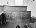 Eiken bank - Culemborg - 20051608 - RCE.jpg 1,200 × 952; 168 KB
-
 Herenstraat Culemborg..jpg 4,770 × 3,177; 4.59 MB
-
 Interieur - Culemborg - 20322440 - RCE.jpg 1,200 × 834; 129 KB
-
 Interieur eiken bank - Culemborg - 20051609 - RCE.jpg 1,200 × 878; 196 KB
-
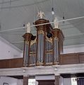 Interieur, aanzicht orgel - Culemborg - 20369089 - RCE.jpg 1,191 × 1,200; 183 KB
-
 Interieur, aanzicht westgevel met orgel - Culemborg - 20369090 - RCE.jpg 806 × 1,200; 137 KB
-
 INTERIEUR, OPGRAVING - Culemborg - 20293439 - RCE.jpg 1,200 × 1,197; 410 KB
-
 INTERIEUR, OPGRAVING - Culemborg - 20293440 - RCE.jpg 1,197 × 1,200; 391 KB
-
 INTERIEUR, OPGRAVING - Culemborg - 20293441 - RCE.jpg 1,191 × 1,200; 398 KB
-
 Kelk - Culemborg - 20051611 - RCE.jpg 948 × 1,200; 169 KB
-
 Kelk - Culemborg - 20051612 - RCE.jpg 962 × 1,200; 185 KB
-
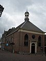
 Luthersekerk Culemborg..jpg 4,356 × 3,177; 2.41 MB
-
 Noord wand naar het westen - Culemborg - 20051882 - RCE.jpg 1,200 × 790; 236 KB
-
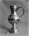 Schenkkan - Culemborg - 20051614 - RCE.jpg 956 × 1,200; 183 KB
-
 Twee zilveren avondmaalskelken - Culemborg - 20051613 - RCE.jpg 1,200 × 898; 173 KB
-
 Westgevel - Culemborg - 20322439 - RCE.jpg 875 × 1,200; 144 KB
-
 Zilveren avondmaalskan - Culemborg - 20051610 - RCE.jpg 873 × 1,200; 173 KB

.jpg)
.jpg)


