Category:Fürst-Brunnen (Bern)
Jump to navigation
Jump to search
| Object location | | View all coordinates using: OpenStreetMap |
|---|
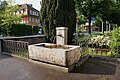
Deutsch: Der Fürst-Brunnen ist ein privater Brunnen in einer Nische zur Strasse hin des Gebäudes Marzilistrasse 27a, Bäckerei Fürst, im Marzili in der Stadt Bern in der Schweiz.
 | |||||
| Upload media | |||||
| Instance of | |||||
|---|---|---|---|---|---|
| Part of | |||||
| Made from material | |||||
| Location | |||||
| Street address |
| ||||
| Owned by |
| ||||
| Operator |
| ||||
| Elevation above sea level |
| ||||
 | |||||
Media in category "Fürst-Brunnen (Bern)"
The following 5 files are in this category, out of 5 total.
-
 Fürst-Brunnen 01.jpg 4,000 × 2,660; 7.94 MB
-
 Fürst-Brunnen 02.jpg 4,000 × 2,662; 8.17 MB
-
 Fürst-Brunnen 03.jpg 4,200 × 2,795; 10.08 MB
-
 Fürst-Brunnen 04.jpg 4,200 × 2,794; 10.48 MB
-
 Fürst-Brunnen 05.jpg 2,861 × 4,300; 9.49 MB


