Category:Failand
Jump to navigation
Jump to search
English: Failand is a village in the English county of Somerset. It falls within the civil parish of Wraxall and Failand and the Unitary Authority of North Somerset.
village in Somerset, England  | |||||
| Upload media | |||||
| Instance of | |||||
|---|---|---|---|---|---|
| Location | Wraxall and Failand, North Somerset, Somerset, South West England, England | ||||
 | |||||
Media in category "Failand"
The following 36 files are in this category, out of 36 total.
-
 A rough track heading down at Ox House Bottom - geograph.org.uk - 3522443.jpg 3,648 × 2,736; 4.37 MB
-
 A spring fed stream at Ox House Bottom - geograph.org.uk - 3522448.jpg 3,648 × 2,736; 4.35 MB
-
 A wandering footpath in Wraxall Piece - geograph.org.uk - 3522407.jpg 3,648 × 2,736; 4.3 MB
-
 Another ornamental pond below Fearney Row - geograph.org.uk - 3522431.jpg 3,648 × 2,736; 3.82 MB
-
 Bristol ^ Clifton Golf Course - geograph.org.uk - 3522405.jpg 3,648 × 2,736; 2.47 MB
-
 Cereal crop at Failand - geograph.org.uk - 3522461.jpg 3,648 × 2,736; 2.33 MB
-
 Clifton Lodge - geograph.org.uk - 127969.jpg 640 × 426; 118 KB
-
 Clifton Lodge.jpg 3,008 × 2,000; 1.51 MB
-
 Entrance barrier at Wraxall Piece - geograph.org.uk - 3522401.jpg 3,648 × 2,736; 4.4 MB
-
 Equestrian facilities-Lower Failand - geograph.org.uk - 2084334.jpg 3,072 × 2,304; 2.7 MB
-
 Failand Coombe - geograph.org.uk - 329734.jpg 640 × 480; 88 KB
-
 Failand Hill - geograph.org.uk - 3275324.jpg 2,560 × 1,920; 3.16 MB
-
 Footpath breaking out of woodland into grazing meadow - geograph.org.uk - 3522452.jpg 3,648 × 2,736; 2.38 MB
-
 Grazing field in Lower Failand - geograph.org.uk - 2084305.jpg 3,072 × 2,304; 2.56 MB
-
 Grazing land at Manor Farm - geograph.org.uk - 3522416.jpg 3,648 × 2,736; 3 MB
-
 Green Lane at Manor Farm - geograph.org.uk - 3522411.jpg 3,648 × 2,736; 3.44 MB
-
 Lower Failand Farm - geograph.org.uk - 2479342.jpg 640 × 480; 80 KB
-
 Manor farm, Failand - geograph.org.uk - 329002.jpg 640 × 480; 65 KB
-
 Meadow above Failand Farm - geograph.org.uk - 3522425.jpg 3,648 × 2,736; 3.1 MB
-
 Moat Cottages - geograph.org.uk - 123752.jpg 640 × 509; 219 KB
-
 Mulberry farm, Lower Failand - geograph.org.uk - 329722.jpg 640 × 489; 85 KB
-
 Ornamental garden below Fearney Row - geograph.org.uk - 3522428.jpg 3,648 × 2,736; 3.6 MB
-
 Post box BS8 1120 (8008675581).jpg 2,347 × 3,347; 1.39 MB
-
 Road scene at Lower Failand - geograph.org.uk - 2083141.jpg 3,072 × 2,304; 3.1 MB
-
 Sandy Lane below Lower Failand - geograph.org.uk - 2086336.jpg 3,072 × 2,304; 4.9 MB
-
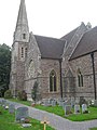 St Bartholomew's Church Lower Failand - geograph.org.uk - 2086354.jpg 2,304 × 3,072; 2.77 MB
-
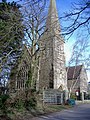 St Bartholomew's, Lower Failand - geograph.org.uk - 329720.jpg 480 × 640; 137 KB
-
 The lowest of three ponds at Fearney Row - geograph.org.uk - 3522435.jpg 3,648 × 2,736; 3.18 MB
-
 The turning to Lower Failand - geograph.org.uk - 2938606.jpg 1,024 × 769; 216 KB
-
 Trackway in Ashton Hill Plantation - geograph.org.uk - 212953.jpg 600 × 450; 145 KB
-
 Weston Road, Failand - geograph.org.uk - 3424785.jpg 979 × 734; 307 KB
-
 Wild Life in Lower Failand - geograph.org.uk - 2084328.jpg 3,072 × 2,304; 3.24 MB
-
 Woodland at Ox House Bottom - geograph.org.uk - 3522438.jpg 3,648 × 2,736; 3.72 MB
-
 Bristol and Clifton golf club - geograph.org.uk - 329761.jpg 640 × 489; 70 KB
-
 Failand Hill House - geograph.org.uk - 127951.jpg 640 × 426; 118 KB
-
 Moat House Farm - geograph.org.uk - 123747.jpg 640 × 480; 190 KB


.jpg)


