Category:Ferme adossée au mur d’enceinte du Château de Font (Chemin des Cibles 21, Châbles)
Jump to navigation
Jump to search
| Object location | | View all coordinates using: OpenStreetMap |
|---|
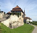
farmhouse in Châbles in the canton of Fribourg, Switzerland  | |||||
| Upload media | |||||
| Instance of | |||||
|---|---|---|---|---|---|
| Part of | |||||
| Location | Châbles, Cheyres-Châbles, Broye District, Canton of Fribourg, Switzerland | ||||
| Street address |
| ||||
| Heritage designation | |||||
 | |||||
Media in category "Ferme adossée au mur d’enceinte du Château de Font (Chemin des Cibles 21, Châbles)"
This category contains only the following file.
-
 Ferme à Châbles.JPG 2,089 × 1,872; 1.32 MB