Category:Flooded roads in Australia
Jump to navigation
Jump to search
Countries of Oceania: Australia
Media in category "Flooded roads in Australia"
The following 13 files are in this category, out of 13 total.
-
 1893 Brisbane flood Queen St.jpg 1,000 × 754; 87 KB
-
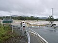
 Beaudesert-Beenleigh Rd at Wolfdene 2013-01-28.jpg 1,000 × 750; 543 KB
-
 Car on Clackline railway bridge 1934.jpg 1,939 × 1,264; 909 KB
-
 CSIRO ScienceImage 10397 Flooded road in the Herbert River catchment northern Queensland.jpg 2,304 × 1,728; 2.85 MB
-
 Flood waters, Gem Road 0.jpg 2,592 × 1,944; 2.1 MB
-
 Flood waters, Gem Road 1.jpg 1,944 × 2,592; 2.02 MB
-
 Flood waters, Gem Road.jpg 2,592 × 1,944; 2.03 MB
-
 Flooding in Showgrounds at Murwillumbah.jpg 1,000 × 750; 602 KB
-
 Flooding on the corner of Euston Lane and Maddox Street Alexandria December 2021.jpg 4,032 × 3,024; 3.18 MB
-
 Karijini National Park, Western Australia (April 2016).jpg 5,312 × 2,988; 5.72 MB
-
 Oxenford - John Muntz Causeway - 28 January 13.jpg 1,000 × 750; 487 KB
-
 Robinson St. Carnarvon - panoramio.jpg 3,072 × 2,048; 1.28 MB
-
 Windsor bridge NSW floods.jpg 566 × 681; 87 KB


.jpg)


