Category:Flora of Southeastern United States
Jump to navigation
Jump to search
Wikimedia category | |||||
| Upload media | |||||
| Instance of | |||||
|---|---|---|---|---|---|
| Category combines topics | |||||
| Category contains | |||||
| flora | |||||
inventory of plant species in a given region   | |||||
| Pronunciation audio | |||||
| Instance of | |||||
| Part of | |||||
| Named after | |||||
| Has part(s) | |||||
| Different from | |||||
 | |||||
Subcategories
This category has the following 106 subcategories, out of 106 total.
.
A
- Asimina longifolia (3 F)
B
C
D
E
F
- Frangula caroliniana (1 P, 6 F)
G
H
- Helianthus divaricatus (19 F)
- Hypericum tenuifolium (1 P, 12 F)
I
J
L
- Lepuropetalon spathulatum (1 F)
- Liatris aspera (1 P, 35 F)
M
N
- Nymphoides cordata (6 F)
O
P
- Pachysandra procumbens (1 P, 45 F)
- Polypodium virginianum (64 F)
Q
R
S
T
- Trillium cuneatum (1 P, 20 F)
U
Pages in category "Flora of Southeastern United States"
The following 4 pages are in this category, out of 4 total.
Media in category "Flora of Southeastern United States"
The following 50 files are in this category, out of 50 total.
-
 Nearctic-Southeastern United States.svg 1,789 × 2,154; 381 KB
-
 Nearctic-Ecozone-Southeastern United States.svg 485 × 367; 36 KB
-
 Appalachian mixed mesophytic forests map.svg 1,712 × 1,992; 342 KB
-
 Appalachian-Blue Ridge forests map.svg 1,712 × 1,992; 343 KB
-
 Appalachian-spruce-fir-zones.png 390 × 252; 5 KB
-
 Middle Atlantic coastal forests map.svg 1,712 × 1,992; 341 KB
-
 Piney Woods Forests map.svg 1,712 × 1,992; 337 KB
-
 Calopogon tuberosus-001.jpg 3,872 × 2,592; 5.39 MB
-
 Calycanthus floridus - sweet shrub - desc-flower.jpg 2,048 × 1,536; 384 KB
-
 Central U.S. Hardwood Forests map.svg 1,712 × 1,992; 345 KB
-
 Cheilanthes lanosa 1 (cropped).jpg 1,271 × 1,694; 802 KB
-
 Cheilanthes lanosa 1.jpg 1,800 × 1,694; 658 KB
-
 Cheilanthes lanosa 2.jpg 600 × 651; 125 KB
-
 Dicentra canadensis.jpg 1,024 × 768; 446 KB
-
 Fagus grandifolia map.png 756 × 613; 45 KB
-
 Fraxinus caroliniana range map.jpg 968 × 830; 322 KB
-
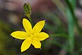 Hypoxis hirsuta.jpg 2,828 × 1,884; 1.53 MB
-
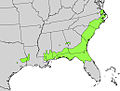
 Ilex amelanchier range map.jpg 857 × 617; 139 KB
-
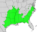
 Ilex cassine range map.jpg 861 × 672; 195 KB
-
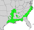
 Ilex coriacea range map.jpg 1,026 × 774; 288 KB
-
 Ilex decidua map.png 692 × 598; 112 KB
-
 Ilex laevigata range map.png 975 × 1,227; 193 KB
-
 Ilex montana range map.jpg 845 × 1,062; 354 KB
-
 Ilex vomitoria range map.jpg 1,085 × 1,369; 281 KB
-
 Liquidambar styraciflua range map 3.png 4,866 × 7,299; 485 KB
-
 Liriodendron tulipifera range map 3.png 3,700 × 3,700; 242 KB
-
 Nyssa aquatica map.png 645 × 567; 102 KB
-
 Nyssa sylvatica range map.jpg 1,326 × 1,782; 816 KB
-
 Osmanthus americanus range map.jpg 799 × 707; 213 KB
-
 Passiflora incarnata map.jpg 1,442 × 1,022; 322 KB
-
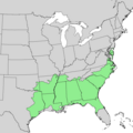
 Persea borbonia range map.jpg 1,172 × 826; 381 KB
-
 Pinus virginiana distribution map.png 1,792 × 1,792; 97 KB
-
 Quercus virginiana range.png 778 × 574; 69 KB
-
 Rhexia virginica seeds, by Omar Hoftun.jpg 4,800 × 3,336; 3.56 MB
-
 Salix nigra map.png 1,006 × 669; 193 KB
-
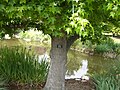
 Sambucus nigra ssp canadensis 1120589.jpg 2,067 × 2,756; 5.8 MB
-
 Sambucus nigra ssp canadensis 1120590.jpg 1,621 × 2,432; 3 MB
-
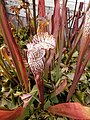 Sarracenia leucophylla pitcher.jpg 675 × 900; 104 KB
-
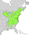
 Staphylea trifolia range map.png 1,160 × 1,322; 291 KB
-
 Stuartia ovata Range.png 736 × 552; 15 KB
-
 Sweet Gum.jpg 2,560 × 1,920; 2.88 MB
-
 Zanthoxylum clava map.png 690 × 571; 99 KB
-
 Asimina parviflora range map 1.png 1,824 × 1,824; 39 KB
-
 Ilex verticillata range map.jpg 1,353 × 1,672; 848 KB
-
 Quercus falcata range map 1.png 1,920 × 1,920; 101 KB
-
 Quercus nigra range map 1.png 1,920 × 1,920; 101 KB
-
 Quercus shumardii range map 1.png 3,516 × 3,516; 197 KB
-
 Quercus virginiana range map 1.png 1,800 × 1,800; 86 KB
-
 Sanguinaria canadensis range map.png 650 × 540; 14 KB
-
 Tsuga canadensis distribution map.png 650 × 540; 14 KB


.jpg)


