Category:Flugplatz Leverkusen
Jump to navigation
Jump to search
| Object location | | View all coordinates using: OpenStreetMap |
|---|
aerodrome in Germany  | |||||
| Upload media | |||||
| Instance of |
| ||||
|---|---|---|---|---|---|
| Named after | |||||
| Location | Flittard, Mülheim, Cologne, Cologne Government Region, North Rhine-Westphalia, Germany | ||||
| Date of official opening |
| ||||
| Elevation above sea level |
| ||||
| ICAO airport code |
| ||||
| official website | |||||
 | |||||
Subcategories
This category has only the following subcategory.
Media in category "Flugplatz Leverkusen"
The following 30 files are in this category, out of 30 total.
-
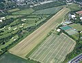 Aerial image of the Leverkusen airfield.jpg 4,400 × 3,400; 6.02 MB
-
 Flugplatz Leverkusen - Schleppflugzeug.jpg 1,000 × 662; 576 KB
-
 Köln - Knochenbergsweg - Flugplatz Leverkusen + Bayer-Kreuz 01 ies.jpg 5,616 × 3,744; 11.06 MB
-
 Köln - Knochenbergsweg - Flugplatz Leverkusen + Bayer-Kreuz 02 ies.jpg 5,616 × 3,744; 15.04 MB
-
 Köln - Knochenbergsweg - Flugplatz Leverkusen + Bayer-Kreuz 03 ies.jpg 5,616 × 3,744; 15.03 MB
-
 Köln - Knochenbergsweg - Flugplatz Leverkusen + Bayer-Kreuz 04 ies.jpg 5,616 × 3,744; 15.2 MB
-
 Köln - Knochenbergsweg - Flugplatz Leverkusen + Bayer-Kreuz 05 ies.jpg 5,616 × 3,744; 14.65 MB
-
 Köln - Knochenbergsweg - Flugplatz Leverkusen + Bayer-Kreuz 06 ies.jpg 5,616 × 3,744; 14.34 MB
-
 Köln - Knochenbergsweg - Flugplatz Leverkusen 01 ies.jpg 5,616 × 3,744; 8.52 MB
-
 Köln - Knochenbergsweg - Flugplatz Leverkusen 02 ies.jpg 5,616 × 3,744; 8.56 MB
-
 Köln - Knochenbergsweg - Flugplatz Leverkusen 03 ies.jpg 5,616 × 3,744; 15.07 MB
-
 Köln - Knochenbergsweg - Flugplatz Leverkusen 04 ies.jpg 5,616 × 3,744; 12.77 MB
-
 Köln - Knochenbergsweg - Flugplatz Leverkusen 05 ies.jpg 5,616 × 3,744; 12.01 MB
-
 Köln - Knochenbergsweg - Flugplatz Leverkusen 08 ies.jpg 5,616 × 3,744; 17.16 MB
-
 Köln - Knochenbergsweg - Flugplatz Leverkusen 09 ies.jpg 5,616 × 3,744; 18.53 MB
-
 Köln - Knochenbergsweg - Flugplatz Leverkusen 10 ies.jpg 3,744 × 5,616; 9.6 MB
-
 Köln - Knochenbergsweg - Flugplatz Leverkusen 11 ies.jpg 5,616 × 3,744; 10.81 MB
-
 Köln - Knochenbergsweg - Flugplatz Leverkusen 12 ies.jpg 5,616 × 3,744; 8.6 MB
-
 Köln - Knochenbergsweg - Flugplatz Leverkusen 14 ies.jpg 5,616 × 3,744; 7.93 MB
-
 Köln - Knochenbergsweg - Flugplatz Leverkusen 15 ies.jpg 5,616 × 3,744; 12.61 MB
-
 Köln - Knochenbergsweg - Flugplatz Leverkusen 16 ies.jpg 5,616 × 3,744; 14.81 MB
-
 Köln - Knochenbergsweg - Flugplatz Leverkusen 17 ies.jpg 5,616 × 3,744; 12.14 MB
-
 Köln - Knochenbergsweg - Flugplatz Leverkusen 18 ies.jpg 5,616 × 3,744; 15.83 MB
-
 Köln - Knochenbergsweg - Flugplatz Leverkusen 19 ies.jpg 5,616 × 3,744; 13.73 MB
-
 Köln - Knochenbergsweg - Flugplatz Leverkusen 20 ies.jpg 5,616 × 3,744; 14.42 MB
-
 Köln - Knochenbergsweg - Flugplatz Leverkusen 21 ies.jpg 5,616 × 3,744; 6.85 MB
-
 Köln - Knochenbergsweg - Flugplatz Leverkusen 22 ies.jpg 5,616 × 3,744; 9.86 MB
-
 Köln - Knochenbergsweg - Flugplatz Leverkusen 23 ies.jpg 5,616 × 3,744; 14.82 MB
-
 Köln - Knochenbergsweg - Flugplatz Leverkusen 24 ies.jpg 5,616 × 3,744; 13.72 MB
-
 Köln - Knochenbergsweg - Flugplatz Leverkusen 25 ies.jpg 5,616 × 3,744; 12.22 MB


