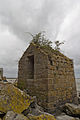
Category:Fontaine Saint-Aubert (Le Mont-Saint-Michel)
Jump to navigation
Jump to search
| Object location | | View all coordinates using: OpenStreetMap |
|---|
|
This building is classé au titre des monuments historiques de la France. It is indexed in the base Mérimée, a database of architectural heritage maintained by the French Ministry of Culture, under the reference PA00110467
|
.jpg) | |||||
| Upload media | |||||
| Instance of | |||||
|---|---|---|---|---|---|
| Location | Le Mont-Saint-Michel, Manche, Normandy, Metropolitan France, France | ||||
| Heritage designation |
| ||||
 | |||||
Media in category "Fontaine Saint-Aubert (Le Mont-Saint-Michel)"
The following 4 files are in this category, out of 4 total.
-
 Brunnen Saint-Aubert 01.jpg 1,606 × 1,117; 538 KB
-
 Brunnen Saint-Aubert 02.jpg 2,298 × 3,327; 2.97 MB
-
 Dos de la fontaine Saint-Aubert (Le Mont-Saint-Michel, Manche, France).jpg 4,576 × 3,051; 6.71 MB
-
 Face de la fontaine Saint-Aubert (Le Mont-Saint-Michel, Manche, France).jpg 3,456 × 5,184; 6.44 MB


.jpg)