Category:Former County Hall, Balassagyarmat
Jump to navigation
Jump to search
|
This is a category about a monument in Hungary. Identifier: 6510 |
| Object location | | View all coordinates using: OpenStreetMap |
|---|
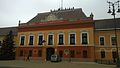
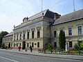
building in Balassagyarmat, Hungary  | |||||
| Upload media | |||||
| Instance of | |||||
|---|---|---|---|---|---|
| Location | Balassagyarmat, Balassagyarmat District, Nógrád County, Hungary | ||||
| Architectural style | |||||
| Date of official opening |
| ||||
 | |||||
Magyar: Balassagyarmati (volt) Vármegyeháza. Balassagyarmat, Civitas Fortissima tér 2. (korbbi címe Köztársaság tér 6!)
Subcategories
This category has the following 2 subcategories, out of 2 total.
Media in category "Former County Hall, Balassagyarmat"
The following 34 files are in this category, out of 34 total.
-
 Balassagyarmat - Megyeháza.jpg 690 × 489; 158 KB
-
 Balassagyarmat 2021 áprilisában12.jpg 3,264 × 2,448; 2.55 MB
-
 Balassagyarmat 2021 áprilisában15.jpg 3,264 × 2,448; 1.71 MB
-
 Balassagyarmat 2021 áprilisában16.jpg 2,182 × 1,568; 743 KB
-
 Balassagyarmat 2021 áprilisában17.jpg 3,264 × 2,448; 1.87 MB
-
 Balassagyarmat 2021 áprilisában18.jpg 2,395 × 1,700; 869 KB
-
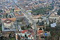 Balassagyarmat légi fotója.jpg 600 × 400; 164 KB
-
 Balassagyarmat vármegyeháza 2.jpg 3,072 × 1,728; 1.74 MB
-
 Balassagyarmat vármegyeháza.jpg 3,072 × 1,728; 1.35 MB
-
 Balassagyarmat, vármegyeháza.jpg 3,968 × 2,976; 1.99 MB
-
 Bgyarmat megyehaza.jpg 1,280 × 960; 141 KB
-
 Bgyarmat Mikszath.jpg 1,280 × 960; 462 KB
-
 Civitas Fortissima Platz 2, 2022 Balassagyarmat.jpg 2,242 × 1,478; 682 KB
-
 Civitas Fortissima Platz 2, Giebel, 2022 Balassagyarmat.jpg 2,272 × 1,704; 1,001 KB
-
 Civitas Fortissima Platz 2, Kulturdenkmal, 2022 Balassagyarmat.jpg 1,804 × 1,362; 475 KB
-
 Civitas Fortissima Platz 2, Madáchstrasse, 2022 Balassagyarmat.jpg 1,567 × 1,120; 370 KB
-
 Civitas Fortissima Platz 2, Schule Namensschild, 2022 Balassagyarmat.jpg 716 × 876; 228 KB
-
 Civitas Fortissima Platz 2, SW, 2022 Balassagyarmat.jpg 2,272 × 1,528; 1.1 MB
-
 Civitas Fortissima Platz, Durchgang, 2022 Balassagyarmat.jpg 1,704 × 2,272; 1,000 KB
-
 Civitas Fortissima Platz, Gedenktafel Iván Nagy, 2022 Balassagyarmat.jpg 1,704 × 2,272; 950 KB
-
 Civitas Fortissima Platz, Gedenktafel Janko Král, 2022 Balassagyarmat.jpg 1,607 × 1,911; 602 KB
-
 Civitas Fortissima Platz, Historische Stätte, 2022 Balassagyarmat.jpg 1,000 × 2,006; 512 KB
-
 Fényképész műterem, háttér a balassagyarmati régi megyeháza. Fortepan 22587.jpg 1,590 × 1,131; 1.1 MB
-

-
 Gedenktafel Miskolczy-Simon, Madáchstrasse, 2022 Balassagyarmat.jpg 2,272 × 1,704; 918 KB
-
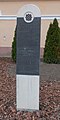
 Historic memorial, County Hall.jpg 1,536 × 2,048; 799 KB
-
 Janko Král plaque (Balassagyarmat Civitas Fortissima tér 2).jpg 2,967 × 2,021; 3.23 MB
-
 Miskolczy-Simon János plaque (Balassagyarmat Civitas Fortissima tér 4).jpg 1,990 × 1,319; 729 KB
-
 Nagy Iván plaque (Balassagyarmat Civitas Fortissima tér 2).jpg 3,026 × 2,055; 3.27 MB
-
 Régi vármegyeháza, Balassagyarmat004.jpg 2,048 × 1,536; 973 KB
-
 Történelmi emlékhely, Balassagyarmat.JPG 2,736 × 3,648; 1.9 MB
-
 Történelmi emlékhely, Vármegyeháza.jpg 1,536 × 2,048; 744 KB
-
 Volt vármegyeháza, Balassagyarmat006.jpg 2,048 × 1,536; 983 KB
-
 Volt Vármegyeháza.JPG 3,648 × 2,736; 2 MB


._Fortepan_29269.jpg)


.jpg)
.jpg)
.jpg)


