Category:Former Pfarrhof Zemling
Jump to navigation
Jump to search
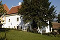
Deutsch: ehemaliger Pfarrhof in Zemling, Gemeinde Hohenwarth-Mühlbach am Manhatsberg
| This category shows the protected monument with the number 12488 in Austria. (Commons, de, Wikidata) |
| Object location | | View all coordinates using: OpenStreetMap |
|---|
 | |||||
| Upload media | |||||
| Instance of | |||||
|---|---|---|---|---|---|
| Location | Hohenwarth-Mühlbach am Manhartsberg, Hollabrunn District, Lower Austria, Austria | ||||
| Street address |
| ||||
| Heritage designation | |||||
 | |||||
Media in category "Former Pfarrhof Zemling"
The following 4 files are in this category, out of 4 total.
-
 Ehemaliger Pfarrhof 12488 in Zemling.jpg 5,447 × 3,770; 4.54 MB
-
 Zemling Pfarrhof.jpg 2,214 × 1,410; 2.03 MB
-
 Zemling Pfarrhof1.jpg 3,008 × 2,000; 3.86 MB
-
 Zemling Pfarrhof2.jpg 3,008 × 2,000; 3.5 MB


