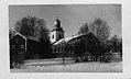
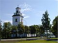
Category:Forsa kyrka
Jump to navigation
Jump to search
| Object location | | View all coordinates using: OpenStreetMap |
|---|
church building in Hudiksvall Municipality, Sweden  | |||||
| Upload media | |||||
| Instance of | |||||
|---|---|---|---|---|---|
| Location | Hudiksvall Municipality, Gävleborg County, Sweden | ||||
| Diocese | |||||
| Has use |
| ||||
| Occupant | |||||
| Heritage designation |
| ||||
 | |||||
Svenska: Forsa kyrka tillhör Forsa-Högs församling, Hälsinglands norra kontrakt, Uppsala stift / Diocese of Uppsala, Sverige / Sweden.
|
This is a category about an ecclesiastical monument in Sweden, number 21300000003994 (sub-number: 21420000041781) in the RAÄ buildings database.
|
Subcategories
This category has the following 2 subcategories, out of 2 total.
H
- Hälsinglands runinskrifter 7 (18 F)
I
- Interior of Forsa kyrka (149 F)
Media in category "Forsa kyrka"
The following 9 files are in this category, out of 9 total.
-
 Forsa - KMB - 16001000329044.jpg 800 × 501; 102 KB
-
 Forsa kyrka - KMB - 16000200036647.jpg 427 × 600; 49 KB
-
 Forsa kyrka - KMB - 16000200036648.jpg 800 × 481; 78 KB
-
 Forsa kyrka - KMB - 16000200036649.jpg 591 × 600; 66 KB
-
 Forsa kyrka - KMB - 16000200036651.jpg 566 × 600; 48 KB
-
 Forsa kyrka - KMB - 16000200036665.jpg 590 × 600; 94 KB
-
 Forsa kyrka - kmb.16000200036643.jpg 800 × 580; 88 KB
-
 Forsa kyrka old1.jpg 572 × 600; 57 KB
-
 Forsakyrka21500001410673.jpg 1,502 × 1,127; 196 KB


Categories:
- Built in Hudiksvall Municipality in 1845
- Churches in the Archdiocese of Uppsala
- Churches in Hälsingland
- Churches in Hudiksvall Municipality
- Churches in Sweden built in 1845
- Jacob Wilhelm Gerss
- Listed churches in Hudiksvall Municipality
- Stone churches in Sweden
- White churches in Sweden
- Aisleless churches in Sweden