Category:Fosse Davy
Jump to navigation
Jump to search
| Object location | | View all coordinates using: OpenStreetMap |
|---|

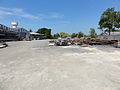
Français : La fosse Davy de la Compagnie des mines d'Anzin était un charbonnage constitué d'un seul puits situé à La Sentinelle, Nord, Nord-Pas-de-Calais, France.
| Upload media | |||||
| Instance of | |||||
|---|---|---|---|---|---|
| Location | La Sentinelle, canton of Valenciennes-Sud | ||||
| Operator | |||||
 | |||||
Subcategories
This category has the following 2 subcategories, out of 2 total.
T
- Terril n° 187, Davy Sud (2 F)
- Terril n° 187A, Davy Nord (2 F)
Media in category "Fosse Davy"
The following 9 files are in this category, out of 9 total.
-
 La Sentinelle - Fosse Davy des mines d'Anzin (01).JPG 3,648 × 2,736; 4.16 MB
-
 La Sentinelle - Fosse Davy des mines d'Anzin (02).JPG 2,736 × 3,648; 3.41 MB
-
 La Sentinelle - Fosse Davy des mines d'Anzin (03).JPG 3,648 × 2,736; 4.24 MB
-
 La Sentinelle - Fosse Davy des mines d'Anzin (04).JPG 3,648 × 2,736; 4.34 MB
-
 La Sentinelle - Fosse Davy des mines d'Anzin (05).JPG 3,648 × 2,736; 4.05 MB
-
 La Sentinelle - Fosse Davy des mines d'Anzin (06).JPG 4,912 × 1,080; 2.52 MB
-
 La Sentinelle - Fosse Davy des mines d'Anzin (A).jpg 1,470 × 1,039; 901 KB
-
 La Sentinelle - Fosse Davy des mines d'Anzin, poste électrique (A).JPG 3,648 × 2,736; 4.27 MB
-
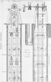 Machine à tacquet 01.png 1,528 × 2,480; 2.84 MB
.JPG)
.JPG)
.JPG)
.JPG)
.JPG)
.jpg)
.JPG)

.JPG)