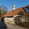
Category:Four (Hameau de Cormanon, Villars-sur-Glâne)
Jump to navigation
Jump to search
| Object location | | View all coordinates using: OpenStreetMap |
|---|
building with oven in Villars-sur-Glâne in the canton of Fribourg, Switzerland  | |||||
| Upload media | |||||
| Instance of | |||||
|---|---|---|---|---|---|
| Part of | |||||
| Location | Villars-sur-Glâne, Sarine District, Canton of Fribourg, Switzerland | ||||
| Street address |
| ||||
| Heritage designation | |||||
| Elevation above sea level |
| ||||
 | |||||
Media in category "Four (Hameau de Cormanon, Villars-sur-Glâne)"
This category contains only the following file.
-
 2021-Villars-sur-Glane-Ofenhaus.jpg 1,280 × 1,280; 2.12 MB