Category:Fraddon
Jump to navigation
Jump to search
village in the United Kingdom  | |||||
| Upload media | |||||
| Instance of | |||||
|---|---|---|---|---|---|
| Location | St Enoder, Cornwall, South West England, England | ||||
 | |||||
English: Fraddon is a village in central Cornwall, United Kingdom. It was situated on the course of the A30 road which is now re-routed south of the village as a dual carriageway bypass). Fraddon is south of the linked villages of St. Columb Road and Indian Queens.
Media in category "Fraddon"
The following 14 files are in this category, out of 14 total.
-
-
 Blue Anchor Inn at Fraddon - geograph.org.uk - 1233033.jpg 640 × 431; 89 KB
-
 Blue Anchor Inn at Fraddon - geograph.org.uk - 30412.jpg 640 × 433; 71 KB
-
 Fraddon Post Office - Post box.JPG 1,224 × 1,632; 282 KB
-
 Higher Fraddon Post box.jpg 1,224 × 1,632; 274 KB
-
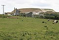
 Pasture and Spoil Heap - geograph.org.uk - 201020.jpg 640 × 429; 78 KB
-
 Spoil Heaps from the China Clay Industry - geograph.org.uk - 201008.jpg 640 × 427; 100 KB
-
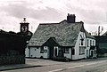
 The Blue Anchor Inn at Fraddon - geograph.org.uk - 1235642.jpg 640 × 480; 64 KB
-
 The Old Road - geograph.org.uk - 226803.jpg 640 × 427; 99 KB
-

-
 Trafalgar Way plaque - geograph.org.uk - 1235650.jpg 480 × 640; 63 KB
-
 Underpass near Fraddon - geograph.org.uk - 198418.jpg 640 × 427; 85 KB
-
 Wheal Remfry China Clay Pit - geograph.org.uk - 229064.jpg 640 × 276; 50 KB
-
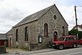 Fraddon Methodist Church - geograph.org.uk - 201033.jpg 640 × 427; 92 KB


