Category:Frankenring 13 (Hostel)
Jump to navigation
Jump to search
| Object location | | View all coordinates using: OpenStreetMap |
|---|
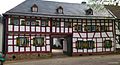
| This category shows a heritage building in Germany, located in the North Rhine-Westphalian city Mechernich (no. 297). |
Media in category "Frankenring 13 (Hostel)"
The following 7 files are in this category, out of 7 total.
-
 Hostel 13.jpg 1,598 × 860; 236 KB
-
 Hostel Frankenring 13 (01).jpg 4,758 × 2,952; 3.22 MB
-
 Hostel Frankenring 13 (02).jpg 5,178 × 3,618; 3.47 MB
-
 Hostel Frankenring 13 (03).jpg 3,690 × 5,814; 3.95 MB
-
 Hostel-am-Anger.JPG 4,288 × 2,848; 5.41 MB
-
 Mechernich - Fachwerk-Bauernhaus 02.JPG 5,472 × 3,080; 3.12 MB
-
 Mechernich - Fachwerk-Bauernhaus.JPG 5,472 × 3,080; 3.37 MB

.jpg)
.jpg)
.jpg)


