Category:Frauenberg (Lauda-Königshofen)
Jump to navigation
Jump to search
| Object location | | View all coordinates using: OpenStreetMap |
|---|
hill in Lauda-Königshofen, Germany   | |||||
| Upload media | |||||
| Instance of | |||||
|---|---|---|---|---|---|
| Location | |||||
 | |||||
Media in category "Frauenberg (Lauda-Königshofen)"
The following 7 files are in this category, out of 7 total.
-
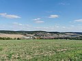 Blick vom Frauenberg auf die Königshöfer Messe 2.jpg 7,296 × 5,472; 12.41 MB
-
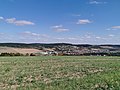
 Blick vom Frauenberg auf die Königshöfer Messe 3.jpg 7,296 × 5,472; 14.61 MB
-
 Blick vom Frauenberg auf die Königshöfer Messe 4.jpg 7,296 × 5,472; 13.12 MB
-
 Blick vom Frauenberg auf die Königshöfer Messe.jpg 3,648 × 2,736; 3.69 MB
-

-

-
 Lage Frauenberg bei Lauda-Königshofen.png 1,859 × 749; 1.18 MB


