Category:Frederikshøj Kro (Taps)
Jump to navigation
Jump to search
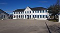
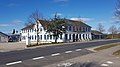
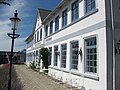
historic inn north of Christiansfeld, Denmark  | |||||
| Upload media | |||||
| Instance of | |||||
|---|---|---|---|---|---|
| Location | Kolding Municipality, Southern Denmark, Denmark | ||||
| Street address |
| ||||
| Located on street |
| ||||
| Legal form | |||||
| official website | |||||
 | |||||
Dansk: Den Gamle Grænsekro 150 m nord for landegrænsen 1864-1920.
Media in category "Frederikshøj Kro (Taps)"
The following 7 files are in this category, out of 7 total.
-
 Den Gamle Grænsekro 01.jpg 4,032 × 2,268; 4.33 MB
-
 Den Gamle Grænsekro 02.jpg 4,032 × 2,268; 5.41 MB
-
 Den Gamle Grænsekro 03.jpg 3,499 × 1,964; 2.93 MB
-
 Frederikshøj Kro - Taps1.JPG 3,648 × 2,736; 2.19 MB
-
 Frederikshøj Kro - Taps2.JPG 3,433 × 2,537; 1.83 MB
-
 Gæstgiveriet Den Gamle Grænsekro Frederikshøj-Indgang.JPG 5,434 × 2,337; 9.72 MB
-
 Gæstgiveriet Den Gamle Grænsekro Frederikshøj.jpg 5,760 × 3,840; 16.97 MB


