Category:Freigut Eschdorf
Jump to navigation
Jump to search
 | |||||
| Upload media | |||||
| Instance of |
| ||||
|---|---|---|---|---|---|
| Location | Dresden, Saxony, Germany | ||||
| Located on street |
| ||||
| Heritage designation | |||||
| Different from | |||||
 | |||||
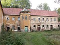
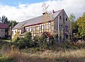
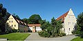
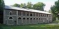
Deutsch: Freigut Eschdorf, auch Quandtsches Gut oder Semperhof, war eine Rittergutsanlage aus der Zeit vor der Reformation. Es wurde 1830 vom Kunsthistoriker Johann Gottlob von Quandt erworben. Das Stallgebäude wurde um 1830 nach Plänen von Gottfried Semper errichtet. Um 2010 saniert und zur Wohnanlage umgebaut.
| (Wikidata) |
| (Wikidata) |
Media in category "Freigut Eschdorf"
The following 35 files are in this category, out of 35 total.
-
 20051017010MDR Eschdorf (Dresden) Freigut Eschdorf Semperhof.jpg 3,687 × 2,057; 5.68 MB
-
 20051017015DR Eschdorf (Dresden) Freigut Eschdorf Semperhof.jpg 2,569 × 1,766; 3.25 MB
-
 20051017017DR Eschdorf (Dresden) Freigut Eschdorf Semperhof.jpg 1,636 × 2,268; 2.42 MB
-
 20051017020DR Eschdorf (Dresden) Freigut Eschdorf Semperhof.jpg 2,560 × 1,913; 2.43 MB
-
 20051017030DR Eschdorf (Dresden) Freigut Eschdorf Semperhof.jpg 2,344 × 1,863; 2.02 MB
-
 20051017035DR Eschdorf (Dresden) Freigut Eschdorf Semperhof.jpg 1,920 × 2,532; 2.43 MB
-
 20051017040DR Eschdorf (Dresden) Freigut Eschdorf Semperhof.jpg 1,791 × 2,382; 2.64 MB
-
 20051017050DR Eschdorf (Dresden) Freigut Eschdorf Semperhof.jpg 2,554 × 1,935; 2.98 MB
-
 20051017055DR Eschdorf (Dresden) Freigut Eschdorf Semperhof.jpg 2,556 × 1,938; 3.01 MB
-
 20051017060DR Eschdorf (Dresden) Freigut Eschdorf Semperhof.jpg 1,933 × 2,612; 2.76 MB
-
 20051017065DR Eschdorf (Dresden) Freigut Eschdorf Semperhof.jpg 1,893 × 2,479; 2.52 MB
-
 20051017070DR Eschdorf (Dresden) Freigut Eschdorf Semperhof.jpg 2,560 × 1,913; 2.56 MB
-
 20051017075DR Eschdorf (Dresden) Freigut Eschdorf Semperhof.jpg 2,560 × 1,905; 2.95 MB
-
 20051017080DR Eschdorf (Dresden) Freigut Eschdorf Semperhof.jpg 1,967 × 2,427; 3.11 MB
-
 20051017085DR Eschdorf (Dresden) Freigut Eschdorf Semperhof.jpg 1,867 × 2,506; 2.24 MB
-
 20051017090DR Eschdorf (Dresden) Freigut Eschdorf Semperhof.jpg 1,770 × 2,475; 2.38 MB
-
 20051017095DR Eschdorf (Dresden) Freigut Eschdorf Semperhof.jpg 2,504 × 1,961; 2.71 MB
-
 20051017100DR Eschdorf (Dresden) Freigut Eschdorf Semperhof.jpg 2,556 × 1,947; 2.02 MB
-
 20051017105DR Eschdorf (Dresden) Freigut Eschdorf Semperhof.jpg 2,560 × 1,919; 2.42 MB
-
 20051017110DR Eschdorf (Dresden) Freigut Eschdorf Semperhof.jpg 1,943 × 2,724; 3.11 MB
-
 20051017115DR Eschdorf (Dresden) Freigut Eschdorf Semperhof.jpg 2,533 × 1,854; 2.65 MB
-
 20051017120DR Eschdorf (Dresden) Freigut Eschdorf Semperhof.jpg 2,536 × 1,784; 2.61 MB
-
 20051017125DR Eschdorf (Dresden) Freigut Eschdorf Semperhof.jpg 2,554 × 1,947; 2.93 MB
-
 20051017130DR Eschdorf (Dresden) Freigut Eschdorf Semperscheune.jpg 2,536 × 1,883; 2.69 MB
-
 20120709100MDR Dresden-Eschdorf Freigut Eschdorf Semperhof.jpg 4,255 × 2,037; 7.85 MB
-
 20120709105MDR Dresden-Eschdorf Freigut Eschdorf Semperhof.jpg 5,126 × 2,112; 8.48 MB
-
 20120709110MDR Dresden-Eschdorf Freigut Eschdorf Semperhof.jpg 3,793 × 1,955; 5.99 MB
-
 20120709115DR Dresden-Eschdorf Freigut Eschdorf Semperhof.jpg 1,752 × 2,388; 4.01 MB
-
 20120709120DR Dresden-Eschdorf Freigut Eschdorf Semperhof.jpg 2,433 × 1,734; 3.72 MB
-
 DD-Eschdorf-Freigut-1.jpg 3,512 × 2,341; 2.03 MB
-
 DD-Eschdorf-Freigut-2.jpg 5,246 × 2,569; 3.65 MB
-
 DD-Eschdorf-Freigut-3.jpg 3,313 × 2,282; 2.05 MB
-
 DD-Eschdorf-Freigut-4.jpg 3,353 × 2,515; 2.51 MB
-
 DD-Eschdorf-Freigut-5.jpg 4,630 × 2,277; 2.91 MB
-
 DD-Eschdorf-Freigut-6.jpg 2,790 × 2,373; 2.19 MB
_Freigut_Eschdorf_Semperhof.jpg)
_Freigut_Eschdorf_Semperhof.jpg)
_Freigut_Eschdorf_Semperhof.jpg)
_Freigut_Eschdorf_Semperhof.jpg)
_Freigut_Eschdorf_Semperhof.jpg)
_Freigut_Eschdorf_Semperhof.jpg)
_Freigut_Eschdorf_Semperhof.jpg)
_Freigut_Eschdorf_Semperhof.jpg)
_Freigut_Eschdorf_Semperhof.jpg)
_Freigut_Eschdorf_Semperhof.jpg)
_Freigut_Eschdorf_Semperhof.jpg)
_Freigut_Eschdorf_Semperhof.jpg)
_Freigut_Eschdorf_Semperhof.jpg)
_Freigut_Eschdorf_Semperhof.jpg)
_Freigut_Eschdorf_Semperhof.jpg)
_Freigut_Eschdorf_Semperhof.jpg)
_Freigut_Eschdorf_Semperhof.jpg)
_Freigut_Eschdorf_Semperhof.jpg)
_Freigut_Eschdorf_Semperhof.jpg)
_Freigut_Eschdorf_Semperhof.jpg)
_Freigut_Eschdorf_Semperhof.jpg)
_Freigut_Eschdorf_Semperhof.jpg)
_Freigut_Eschdorf_Semperhof.jpg)
_Freigut_Eschdorf_Semperscheune.jpg)


