Category:Friedhof Weißkirchen (Oberursel)
Jump to navigation
Jump to search
This is the category of the Hessian Kulturdenkmal (cultural monument) with the ID Unknown? (Wikidata)
|
| Object location | | View all coordinates using: OpenStreetMap |
|---|
| Upload media | |||||
| Instance of | |||||
|---|---|---|---|---|---|
| Location | Oberursel (Taunus), Hochtaunuskreis, Darmstadt Government Region, Hesse, Germany | ||||
 | |||||
Media in category "Friedhof Weißkirchen (Oberursel)"
The following 8 files are in this category, out of 8 total.
-
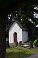
 Weißkirchen, Friedhof (1).JPG 3,264 × 4,928; 6.49 MB
-
 Weißkirchen, Friedhof, (2).JPG 3,264 × 4,928; 6.03 MB
-
 Weißkirchen, Friedhof, Grab Pfarrer Mosel.JPG 3,264 × 4,928; 8.17 MB
-
 Weißkirchen, Friedhof, Grab Pfarrer Reichwein.JPG 4,928 × 3,264; 8.71 MB
-
 Weißkirchen, Friedhof, Grab Pfarrer Scheh Schieler.JPG 3,264 × 4,928; 8.96 MB
-
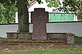 Weißkirchen, Friedhof, Kriegstotengedenkkreuz.JPG 4,928 × 3,264; 8.91 MB
-
 Weißkirchen, Friedhof, Kruzifix.JPG 3,264 × 4,928; 6.87 MB
-
 Weißkirchen, Friedhof.JPG 4,928 × 3,264; 8.07 MB
.JPG)
.JPG)


