Category:Friedrich Ebert-Straße 20 (Kronberg)
Jump to navigation
Jump to search
| Object location | | View all coordinates using: OpenStreetMap |
|---|
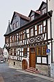
This is the category of the Hessian Kulturdenkmal (cultural monument) with the ID 99889 (Wikidata)
|
 | |||||
| Upload media | |||||
| Instance of | |||||
|---|---|---|---|---|---|
| Location | Kronberg im Taunus, Hochtaunuskreis, Darmstadt Government Region, Hesse, Germany | ||||
| Heritage designation | |||||
 | |||||
Media in category "Friedrich Ebert-Straße 20 (Kronberg)"
The following 12 files are in this category, out of 12 total.
-
 Friedrich-Ebert-Strasse-20-Kronberg-JR-E-5102-2021-05-08.jpg 2,547 × 3,432; 3.56 MB
-
 Friedrich-Ebert-Strasse-20-Kronberg-JR-E-5119-2021-05-08.jpg 2,893 × 4,364; 4.88 MB
-
 Friedrich-Ebert-Strasse-20-Kronberg-JR-E-5138-2021-05-08.jpg 2,020 × 4,439; 4.44 MB
-
 Friedrich-Ebert-Strasse-20-Kronberg-JR-T20-1564-2021-10-23.jpg 4,012 × 6,018; 12.39 MB
-
 Kronberg im Taunus, die Doppesstraße (südliches Ende).JPG 1,697 × 2,604; 2.63 MB
-
 Kronberg im Taunus, Erker am Haus Friedrich-Ebert-Straße 20.JPG 1,227 × 2,949; 728 KB
-
 Kronberg, Friedrich Ebert-Straße 20 (1).JPG 3,262 × 4,917; 5.85 MB
-
 Kronberg, Friedrich-Ebert-Straße 20 (2).jpg 4,884 × 5,236; 19.32 MB
-
 Kronberg, Friedrich-Ebert-Straße 20, Stolperstein Georg Krug.jpg 4,119 × 2,871; 4.98 MB
-
 Kronberg, Friedrich-Ebert-Straße 20.jpg 4,884 × 5,181; 12.5 MB
-
 Luthmer II-108-Kronberg Erker am Haus drei Ritter (nach Reiffenstein 1836).jpg 751 × 1,754; 912 KB
-
 Luthmer II-109-Kronberg Konsole am Haus drei Ritter.jpg 989 × 1,820; 1.3 MB


.JPG)

.JPG)
.jpg)


.jpg)
