Category:Fronveststraße 12 (Herrieden)
Jump to navigation
Jump to search
| Object location | | View all coordinates using: OpenStreetMap |
|---|
 | |||||
| Upload media | |||||
| Instance of | |||||
|---|---|---|---|---|---|
| Location | Herrieden, Ansbach, Middle Franconia, Bavaria, Germany | ||||
| Street address |
| ||||
| Heritage designation | |||||
 | |||||
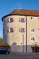
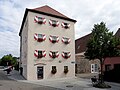
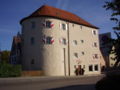
This is the category of the Bavarian Baudenkmal (cultural heritage monument) with the ID D-5-71-166-13 (Wikidata)
|
Deutsch: Herrieden - Fronveststraße 12 - Ehemaliger Stadtturm mit Gefängnis, später Wohngebäude, viergeschossiges Walmdachgebäude mit halbrundem Abschluss, teilweise 15. Jahrhundert; zugehörig Stadtbefestigung.
Media in category "Fronveststraße 12 (Herrieden)"
The following 16 files are in this category, out of 16 total.
-
 D-5-71-166-13 Herrieden 20220219 0072.jpg 5,650 × 3,759; 19.35 MB
-
 D-5-71-166-13 Herrieden 20220219 0073.jpg 3,613 × 5,430; 17.55 MB
-
 D-5-71-166-13 Herrieden 20220219 0074.jpg 3,669 × 5,515; 18.04 MB
-
 D-5-71-166-13 Herrieden 20220219 0075.jpg 3,616 × 5,434; 15.69 MB
-
 D-5-71-166-13 Herrieden 20220219 0076.jpg 3,601 × 5,413; 15.93 MB
-
 D-5-71-166-13 Herrieden 20220219 0077.jpg 3,642 × 5,473; 16.8 MB
-
 D-5-71-166-13 Herrieden 20220219 0078.jpg 5,810 × 3,866; 16.2 MB
-
 Herrieden Fronfeste von SW.jpg 3,054 × 2,291; 2.71 MB
-
 Herrieden, Fronveststraße 12-001.jpg 3,264 × 4,928; 7.3 MB
-
 Herrieden, Fronveststraße 12-002.jpg 3,264 × 4,928; 7.41 MB
-
 Herrieden, Fronveststraße 12-003.jpg 3,264 × 4,928; 8.12 MB
-
 Herrieden, Fronveststraße 12-004.jpg 4,928 × 3,264; 6.79 MB
-
 Herrieden, Fronveststraße 12-005.jpg 3,264 × 4,928; 7.9 MB
-
 Herrieden, Fronveststraße 12-006.jpg 4,928 × 3,264; 7.26 MB
-
 HerriedenFronvesteSüdseite.jpg 1,920 × 2,560; 1.03 MB
-
 HerriedenVeste.jpg 2,560 × 1,920; 1,003 KB


