Category:Frucht- und Mehlbörse, Café Schottenring, Vienna
Jump to navigation
Jump to search
| Object location | | View all coordinates using: OpenStreetMap |
|---|
 | |||||
| Upload media | |||||
| Instance of | |||||
|---|---|---|---|---|---|
| Location | Innere Stadt, Vienna, Austria | ||||
| Street address |
| ||||
| Heritage designation | |||||
 | |||||
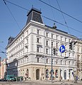
Deutsch: Haus Schottenring 19 (= Börsegasse 16-18, Maria-Theresien-Straße 20) in Wien, erbaut 1879 von Rudolf Neumayr.
Media in category "Frucht- und Mehlbörse, Café Schottenring, Vienna"
The following 7 files are in this category, out of 7 total.
-
 Börsegasse 15.JPG 3,072 × 2,304; 4.07 MB
-
 Ehem. Frucht- und Mehlbörse mit Bim.jpg 800 × 462; 289 KB
-
 Ehem. Frucht- und Mehlbörse Rückseite.jpg 800 × 506; 321 KB
-
 Ehem. Frucht- und Mehlbörse.jpg 800 × 549; 345 KB
-
 P1120848 27.09.2015 PARADE 150 Jahre Tramway G 777.jpg 1,200 × 900; 810 KB
-
 Schottenring 19.jpg 4,507 × 4,666; 7.02 MB
-
 Schottenring19.jpg 4,000 × 3,000; 2.71 MB


