Category:Gündlischwand
Jump to navigation
Jump to search
municipality in the canton of Bern in Switzerland    | |||||
| Upload media | |||||
| Instance of | |||||
|---|---|---|---|---|---|
| Location |
| ||||
| Official language | |||||
| Population |
| ||||
| Area |
| ||||
| Elevation above sea level |
| ||||
| official website | |||||
 | |||||
Subcategories
This category has the following 5 subcategories, out of 5 total.
H
S
Z
Media in category "Gündlischwand"
The following 19 files are in this category, out of 19 total.
-
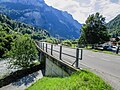
 Alte Dorfbrücke über die Schwarze Lütschine, Gündlischwand BE 20240624-jag9889.jpg 5,152 × 3,864; 13.84 MB
-
 B.O.B - panoramio.jpg 1,200 × 803; 241 KB
-
 BOB SPB - panoramio - Jakkes (1).jpg 800 × 600; 254 KB
-
 Buechisteg über die Schwarze Lütschine, Gündlischwand BE 20240624-jag9889.jpg 4,746 × 3,560; 15.51 MB
-
 Early morning Eiger Mönch Jungfrau from Schynige Platte - panoramio.jpg 3,890 × 640; 426 KB
-
 ETH-BIB-Krachen zw. Oberberghorn und Laucherhorn-Dia 247-05455.tif 3,600 × 2,835; 9.84 MB
-
 ETH-BIB-Oberberghorn Laucherhorn von der Schynigen Platte-Dia 247-05318.tif 3,632 × 2,648; 27.62 MB
-
 ETH-BIB-Sägistal-See und Schwabhorn-Dia 247-05456.tif 3,626 × 2,556; 26.62 MB
-
 ETH-BIB-Sägistalsee, Brienzersee-Dia 247-05457.tif 3,145 × 3,355; 30.32 MB
-
 ETH-BIB-Sägistalsee, Thunersee-Dia 247-01871.tif 3,527 × 2,844; 9.64 MB
-
 Fussgängerbrücke über die Schwarze Lütschine, Gündlischwand BE 20240624-jag9889.jpg 5,152 × 3,864; 20.12 MB
-
 Hauptstrasse-Brücke über die Schwarze Lütschine, Gündlischwand BE 20240624-jag9889.jpg 5,152 × 3,864; 16.38 MB
-
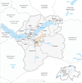 Karte Gemeinde Gündlischwand 2007.png 1,181 × 1,194; 351 KB
-
 Karte Gemeinde Gündlischwand 2010.png 1,476 × 1,153; 563 KB
-

-
 Swiss Hiking Network - Signpost - Daube.jpg 4,032 × 3,024; 2.47 MB
-
 Swiss Hiking Network - Signpost - Grat.jpg 4,032 × 3,024; 2.97 MB
-
 Swiss Hiking Network - Signpost - Lauchere Grätli.jpg 4,032 × 3,024; 2.45 MB
-
 Sägistalsee 2015.jpg 1,024 × 649; 285 KB


.jpg)


.jpg)


