Category:Gare d'Arvant
Jump to navigation
Jump to search
| Object location | | View all coordinates using: OpenStreetMap |
|---|
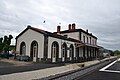
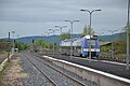
railway station in Bournoncle-Saint-Pierre, France  | |||||
| Upload media | |||||
| Instance of | |||||
|---|---|---|---|---|---|
| Location | Bournoncle-Saint-Pierre, canton of Brioude-Nord | ||||
| Transport network | |||||
| Owned by | |||||
| Operator | |||||
| Date of official opening |
| ||||
| Elevation above sea level |
| ||||
| Connecting line | |||||
| Adjacent station | |||||
 | |||||
Français : La gare d'Arvant est une gare ferroviaire des lignes de Saint-Germain-des-Fossés à Nîmes-Courbessac et de Figeac à Arvant, située sur la commune de Bournoncle-Saint-Pierre, dans le département la Haute-Loire en région Auvergne-Rhône-Alpes.
Media in category "Gare d'Arvant"
The following 8 files are in this category, out of 8 total.
-
 Gare d'Arvant 07.jpg 4,000 × 3,000; 3.8 MB
-
 Gare d'Arvant 08.jpg 4,000 × 3,000; 4.74 MB
-
 Gare d'Arvant 1.jpg 4,608 × 3,072; 4.27 MB
-
 Gare d'Arvant 2.jpg 4,608 × 3,072; 4.98 MB
-
 Gare d'Arvant 3.jpg 4,608 × 3,072; 5.08 MB
-
 Gare d'Arvant 4.jpg 4,608 × 3,072; 5.24 MB
-
 Gare d'Arvant 5.jpg 4,608 × 3,072; 5.05 MB
-
 Gare d'Arvant 6.jpg 4,608 × 3,072; 5.42 MB


