Category:Gebäude (nach 1575) (Aarbergergasse 24, Bern)
Jump to navigation
Jump to search
| Object location | | View all coordinates using: OpenStreetMap |
|---|
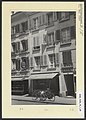
alley building in Aarbergasse in the old town of Bern, Switzerland  | |||||
| Upload media | |||||
| Instance of |
| ||||
|---|---|---|---|---|---|
| Part of | |||||
| Location | Aarbergergasse, Red Quarter, Inner City, Bern, Bern-Mittelland administrative district, Bernese Mittelland administrative region, Bern, Switzerland | ||||
| Street address |
| ||||
| Located on street |
| ||||
| Architectural style |
| ||||
| Heritage designation |
| ||||
| Inception |
| ||||
 | |||||
Media in category "Gebäude (nach 1575) (Aarbergergasse 24, Bern)"
The following 3 files are in this category, out of 3 total.
-
 Aarbergergasse 24 in Bern.jpg 2,250 × 4,000; 5.15 MB
-
 Stadtarchiv-Bern SAB 1038 16 1 95-Aarbergergasse-24-31.05.1946.jpg 1,816 × 2,542; 596 KB
-
 Stadtarchiv-Bern SAB 1038 16 1 96-Aarbergergasse-24-und-26-25.04.1945.jpg 1,831 × 2,563; 543 KB

