Category:Gemeentehuis (Gilze)
Jump to navigation
Jump to search
| Object location | | View all coordinates using: OpenStreetMap |
|---|
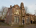
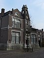
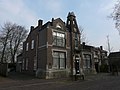
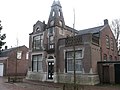
Nederlands: Afbeeldingen van het 't Oude Raadhuis het voormalige gemeentehuis (Gilze), Nieuwstraat 22, 5126 CE Gilze. Gelegen in Gilze behorende tot de gemeente Gilze en Rijen in de provincie Noord-Brabant in het zuiden van Nederland. Het is een rijksmonument. Tegenwoordig zijn hier gevestigd de Heemkring Molenheide en de Stichting Dagopvang Gilze, Nieuwstraat 22, 5126 CE Gilze. (bron [1])
|
This is a category about rijksmonument number 516971
|
 | |||||
| Upload media | |||||
| Instance of | |||||
|---|---|---|---|---|---|
| Location | Gilze, Gilze en Rijen, North Brabant, Netherlands | ||||
| Street address |
| ||||
| Located on street |
| ||||
| Heritage designation |
| ||||
 | |||||
Media in category "Gemeentehuis (Gilze)"
The following 4 files are in this category, out of 4 total.
-
 516971 het oude raadhuis.jpg 3,000 × 2,318; 6 MB
-
 Gilze P1060303.JPG 2,448 × 3,264; 3.59 MB
-
 Gilze P1060304.JPG 3,264 × 2,448; 3.76 MB
-
 Voormalig Gemeentehuis Gilze.JPG 2,816 × 2,112; 1.49 MB


