Category:Gemeenteweg 106, Staphorst
Jump to navigation
Jump to search
| Object location | | View all coordinates using: OpenStreetMap |
|---|
_RM-34253-WLM.jpg) | |||||
| Upload media | |||||
| Instance of | |||||
|---|---|---|---|---|---|
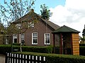
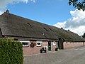
| Location | Staphorst, Overijssel, Netherlands | ||||
| Street address |
| ||||
| Located on street |
| ||||
| Heritage designation |
| ||||
 | |||||
|
This is a category about rijksmonument number 34253
|
| Address |
|
Media in category "Gemeenteweg 106, Staphorst"
The following 7 files are in this category, out of 7 total.
-
 Aanzicht - Staphorst - 20203985 - RCE.jpg 1,200 × 809; 235 KB
-
 Linker zij- en achtergevel - Staphorst - 20203987 - RCE.jpg 1,195 × 1,200; 234 KB
-
 Makelaar bij schoorsteen - Staphorst - 20447279 - RCE.jpg 732 × 891; 74 KB
-
 Staphorst, Gemeenteweg 106 (1) RM-34253-WLM.jpg 3,648 × 2,736; 2.51 MB
-
 Staphorst, Gemeenteweg 106 (2) RM-34253-WLM.jpg 3,648 × 2,736; 2.47 MB
-
 Voor- en rechter zijgevel - Staphorst - 20203986 - RCE.jpg 1,195 × 1,200; 299 KB
-
 Zij- en voorgevel - Staphorst - 20447278 - RCE.jpg 1,200 × 900; 110 KB


_RM-34253-WLM.jpg)

