Category:Gemeenteweg 148, Staphorst
Jump to navigation
Jump to search
| Object location | | View all coordinates using: OpenStreetMap |
|---|
 | |||||
| Upload media | |||||
| Instance of | |||||
|---|---|---|---|---|---|
| Location | Staphorst, Overijssel, Netherlands | ||||
| Street address |
| ||||
| Located on street |
| ||||
| Heritage designation |
| ||||
 | |||||
|
This is a category about rijksmonument number 34256
|
| Address |
|
Media in category "Gemeenteweg 148, Staphorst"
The following 7 files are in this category, out of 7 total.
-
 Aanzicht - Staphorst - 20204028 - RCE.jpg 1,200 × 810; 209 KB
-
 Achtergevel - Staphorst - 20204031 - RCE.jpg 1,195 × 1,200; 410 KB
-
 Linker zijgevel - Staphorst - 20204030 - RCE.jpg 1,195 × 1,200; 339 KB
-
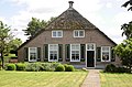 Staphorst - Gemeenteweg 148 RM34256.JPG 4,533 × 3,000; 1.48 MB
-
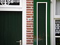 Staphorst, Gemeenteweg 148 (detail) RM-34256-WLM.jpg 3,648 × 2,736; 2.24 MB
-
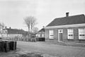 Van links naar rechts overzicht - Staphorst - 20204032 - RCE.jpg 1,200 × 811; 190 KB
-
 Voorgevel - Staphorst - 20204029 - RCE.jpg 1,185 × 1,200; 367 KB


_RM-34256-WLM.jpg)

