Category:Gentsepoort, Hulst
Jump to navigation
Jump to search
| Object location | | View all coordinates using: OpenStreetMap |
|---|
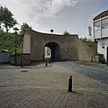
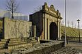
Nederlands: Afbeeldingen van de stadspoort de Gentsepoort in Hulst in de provincie Zeeland in het zuidwesten van Nederland. In het midden staat het wapenschild met de Generaliteitsleeuw van de Republiek der Zeven Verenigde Nederlanden. Gelegen nabij de straten de Stationsweg en de Gentsepoort
|
This is a category about rijksmonument number 22736
|
 | |||||
| Upload media | |||||
| Instance of | |||||
|---|---|---|---|---|---|
| Location | Hulst, Zeeland, Netherlands | ||||
| Street address |
| ||||
| Heritage designation |
| ||||
 | |||||
Subcategories
This category has only the following subcategory.
D
Media in category "Gentsepoort, Hulst"
The following 21 files are in this category, out of 21 total.
-
 ANWB informatieborden Hulst 02.jpg 5,472 × 3,648; 10.94 MB
-
 ANWB informatieborden Hulst 03.jpg 5,472 × 3,648; 7.97 MB
-
 Detail binnenzijde Gentse Poort- bovengedeelte met attieken - Hulst - 20378142 - RCE.jpg 1,200 × 1,200; 237 KB
-
 Exterieur OVERZICHT - Hulst - 20309435 - RCE.jpg 1,195 × 1,200; 291 KB
-
 Gentse poort (buiten) - Hulst - 20118598 - RCE.jpg 1,200 × 880; 252 KB
-
 Gentse poort hulst-1554791342.jpg 2,362 × 1,574; 766 KB
-
 Gentse Poort te Hulst.jpg 3,543 × 2,362; 1.31 MB
-
 Gentse poort, Landzijde - Hulst - 20118599 - RCE.jpg 1,200 × 899; 294 KB
-
 Gentsepoort Hulst 01.jpg 3,648 × 5,472; 19.22 MB
-
 Gentsepoort Hulst 05.jpg 3,648 × 5,472; 12.27 MB
-
 Gentsepoort, aanzicht - Hulst - 20118601 - RCE.jpg 1,200 × 809; 275 KB
-
 Hulst, de Gentse Poort in straatzicht RM22736 foto4 2013-05-06 14.05.jpg 4,357 × 3,287; 11.37 MB
-
 HulstHoofdpoort.JPG 1,712 × 2,288; 818 KB
-
 Overzicht binnenzijde Gentse Poort - Hulst - 20378139 - RCE.jpg 1,200 × 1,200; 381 KB
-
 Overzicht binnenzijde Gentse Poort - Hulst - 20378140 - RCE.jpg 1,200 × 1,200; 313 KB
-
 Overzicht Gentse Poort - Hulst - 20378131 - RCE.jpg 1,200 × 1,200; 332 KB
-
 Overzicht Gentse Poort-, buitenzijde - Hulst - 20378137 - RCE.jpg 1,200 × 1,200; 324 KB
-
 Overzicht poort - Hulst - 20118600 - RCE.jpg 1,200 × 894; 294 KB
-
-

-


_-_Hulst_-_20118598_-_RCE.jpg)


,_Rijksarchief_Den_Haag,_inv.nr.821,_kast_C._portef._X_-_Hulst_-_20118582_-_RCE.jpg)