Category:Gentsestraat 10, Hulst
Jump to navigation
Jump to search
| Object location | | View all coordinates using: OpenStreetMap |
|---|
building in Hulst, Netherlands  | |||||
| Upload media | |||||
| Instance of | |||||
|---|---|---|---|---|---|
| Location | Hulst, Zeeland, Netherlands | ||||
| Street address |
| ||||
| Located on street | |||||
| Heritage designation |
| ||||
 | |||||
|
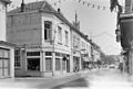
This is a category about rijksmonument number 22743
|
| Address |
|
Media in category "Gentsestraat 10, Hulst"
The following 3 files are in this category, out of 3 total.
-
 Hulst - rijksmonument 22743 - Gentsestraat 10 20120714.jpg 555 × 800; 229 KB
-
 Overzicht - Hulst - 20118784 - RCE.jpg 1,200 × 811; 190 KB
-
 Voorgevels - Hulst - 20118792 - RCE.jpg 807 × 1,200; 215 KB

