<nowiki>Category:Geography of Toyoake; Category:豊明市の地理; categoría de Wikimedia; Wikimedia category; категория на Уикимедия; categorie a unui proiect Wikimedia; 維基媒體分類; kategória projektov Wikimedia; категорія проєкту Вікімедіа; kawan Wikimèdia; 維基媒體分類; 维基媒体分类; Wikimedia-Kategorie; 위키미디어 분류; kategorio en Vikimedio; Викимедиина категорија; kategorija na Wikimediji; categoría de Wikimedia; উইকিমিডিয়া বিষয়শ্রেণী; page de catégorie de Wikimedia; kategorija na Wikimediji; 维基媒体分类; וויקימעדיע קאַטעגאָריע; thể loại Wikimedia; Wikimedia projekta kategorija; Wikimedia-kategorie; категорија на Викимедији; categoria de um projeto da Wikimedia; Wikimedia category; Wikimedia-Kategorie; Wikimedia-kategori; Wikimedia-kategori; پۆلی ویکیمیدیا; Wikimedia category; تصنيف ويكيميديا; pajenn rummata eus Wikimedia; 維基媒體分類; Wikimedia категориясы; વિકિપીડિયા શ્રેણી; Wikimediako kategoria; categoría de Wikimedia; Wikimedia-categorie; Викимедиа категорияһы; tudalen categori Wikimedia; катэгорыя ў праекце Вікімедыя; Վիքիմեդիայի նախագծի կատեգորիա; 维基媒体分类; Wikimedia-kategory; ウィキメディアのカテゴリ; Wikimedia-Kategorie; катэгорыя ў праекце Вікімэдыя; קטגוריה במיזמי ויקימדיה; κατηγορία εγχειρημάτων Wikimedia; Wikimedia-Kategorie; विकिमीडिया श्रेणी; categurìa 'e nu pruggette Wikimedia; Wikimedia-luokka; гурӯҳи Викимедиа; Wikimedia-categorie; kategorie na projektech Wikimedia; guruhi Vikimedia; categoria di un progetto Wikimedia; Wikimedia category; Wikimedia-kategori; Vikimedya kategorisi; 維基媒體分類; Wikimedia-categorie; ردهٔ ویکیپدیا; kategoria w projekcie Wikimedia; kategori e Wikimedias; ẹ̀ka Wikimedia; Wikimedia-Kategorie; categoria de um projeto da Wikimedia; Wikimedia-Kategorie; categoria de Wikimedia; tumbung Wikimedia; kategoria ti Wikimedia; kategorija Wikimedie; Wikimédia-kategória; категория в проекте Викимедиа; Wikimedia-kategoriija; kategori Wikimedia; jamii ya Wikimedia; Wikimedia-kategori; 維基媒體分類; kategori Wikimedia; Wikimedia kategooria; विकिपीडिया:श्रेणी; Wikimedia-Kategorie; categoría de Wikimedia; гурӯҳи Викимедиа; 维基媒体分类; 维基媒体分类</nowiki>
 Aichi toyoake it.png 1,181 × 901; 71 KB
 Aichi-toyoake-city.svg 561 × 506; 26 KB
 Map of Administrative Districts in Toyoake-City 2018.png 2,810 × 3,250; 983 KB
 Map of Districts in Toyoake-City 2018.png 2,810 × 3,250; 1.4 MB
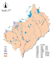 Map of the Main Rivers and the Basins in Toyoake City 2018.png 2,810 × 3,250; 930 KB
 Okehazamakosenjoumatsuri.JPG 3,600 × 2,700; 1.71 MB
 Toyoake city center area Aerial photograph.1987.jpg 4,370 × 5,806; 20.23 MB
 Toyoake city center area Aerial photograph.2020.jpg 8,624 × 10,130; 61.14 MB
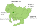
 Toyoake in Aichi Prefecture Ja.svg 539 × 484; 21 KB
 Welcome Signboard of Toyoake City 2018.jpg 1,600 × 1,200; 2.33 MB
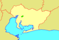 地図-愛知県豊明市-2006.png 300 × 205; 6 KB
 基礎自治体位置図 23229-2.svg 539 × 484; 13 KB


