Category:Geography of Tsushima, Aichi
Jump to navigation
Jump to search
Wikimedia category | |||||
| Upload media | |||||
| Instance of | |||||
|---|---|---|---|---|---|
| |||||
日本語: 愛知県津島市の地理。
Subcategories
This category has the following 7 subcategories, out of 7 total.
*
A
- Ama Main Waterway (4 F)
C
H
- Honmachi Street (Tsushima) (13 F)
P
T
- Tenno Street (Tsushima) (10 F)
Media in category "Geography of Tsushima, Aichi"
The following 20 files are in this category, out of 20 total.
-
 Above Sea Level -1.8m 20161217.jpg 5,472 × 3,648; 3.82 MB
-
 Aichi tsushima it.png 1,181 × 901; 70 KB
-
 Aichi tsushima lt.png 1,181 × 901; 48 KB
-
 Aichi-tsushima-city.svg 561 × 506; 26 KB
-
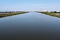 Nikko River from Kabuto Bridge.jpg 3,200 × 2,133; 1.44 MB
-
 Skyline of Tsushima01.jpg 4,032 × 3,024; 1.54 MB
-
 Tabacco Vendor Machine 20170103.jpg 3,648 × 5,472; 5.52 MB
-
 Tsushima city Aichi Prefecture center area Aerial photograph.1987.jpg 5,758 × 3,438; 14.79 MB
-
 Tsushima City Sewer Manhole 20170103.jpg 5,472 × 3,648; 7.38 MB
-
 Tsushima Ginza Shopping Street 1957.jpg 1,237 × 919; 374 KB
-
 Tsushima Ginza Shopping Street 1966.jpg 1,273 × 904; 360 KB
-
 Tsushima Hashizumemachi Shopping Street 1966.jpg 1,289 × 901; 407 KB
-
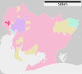
 Tsushima in Aichi Prefecture Ja.svg 539 × 484; 21 KB
-
 Tsushima Lotus roots 1957.jpg 987 × 1,466; 470 KB
-
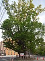 Tsushima-jinja sacred tree 2021-06 ac (1).jpg 3,826 × 5,102; 4.31 MB
-
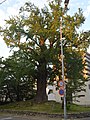 Tsushima-jinja sacred tree 2021-06 ac (2).jpg 3,664 × 4,885; 3.66 MB
-
 Tsushima-jinja sacred tree 2021-06 ac (3).jpg 5,820 × 3,869; 3.73 MB
-
 ヨシヅヤ 創業時の看板.jpg 2,160 × 3,840; 2.46 MB
-
 地図-愛知県津島市-2006.png 300 × 205; 6 KB
-
 基礎自治体位置図 23208-2.svg 539 × 484; 13 KB


.jpg)
.jpg)
.jpg)