Category:Geology of New York (state)
Jump to navigation
Jump to search
Wikimedia category | |||||
| Upload media | |||||
| Instance of | |||||
|---|---|---|---|---|---|
| Category combines topics | |||||
| New York | |||||
state of the United States of America  The New York State Capitol in Albany   .svg)   | |||||
| Pronunciation audio | |||||
| Instance of |
| ||||
| Part of | |||||
| Named after | |||||
| Location |
| ||||
| Located in or next to body of water | |||||
| Capital | |||||
| Legislative body | |||||
| Executive body | |||||
| Highest judicial authority | |||||
| Head of government |
| ||||
| Inception |
| ||||
| Highest point | |||||
| Population |
| ||||
| Area |
| ||||
| Elevation above sea level |
| ||||
| Replaces |
| ||||
| Different from | |||||
| Maximum temperature record |
| ||||
| Minimum temperature record |
| ||||
| official website | |||||
 | |||||
States of the United States: Alabama · Alaska · Arizona · Arkansas · California · Colorado · Connecticut · Delaware · Florida · Georgia (U.S. state) · Hawaii · Idaho · Illinois · Indiana · Iowa · Kansas · Kentucky · Louisiana · Maine · Maryland · Massachusetts · Michigan · Minnesota · Mississippi (state) · Missouri · Montana · Nebraska · Nevada · New Hampshire · New Jersey · New Mexico · New York (state) · North Carolina · North Dakota · Ohio · Oklahoma · Oregon · Pennsylvania · Rhode Island · South Carolina · South Dakota · Tennessee · Texas · Utah · Vermont · Virginia · Washington (state) · West Virginia · Wisconsin · Wyoming – the District of Columbia: Washington, D.C.
the insular areas of the United States: American Samoa · Guam · the Northern Mariana Islands · Puerto Rico · the United States Virgin Islands – the United States Minor Outlying Islands: Bajo Nuevo Bank · Baker Island · Howland Island · Jarvis Island · Johnston Atoll · Kingman Reef · Midway Atoll · Navassa Island · Palmyra Atoll · Serranilla Bank · Wake Island
the insular areas of the United States: American Samoa · Guam · the Northern Mariana Islands · Puerto Rico · the United States Virgin Islands – the United States Minor Outlying Islands: Bajo Nuevo Bank · Baker Island · Howland Island · Jarvis Island · Johnston Atoll · Kingman Reef · Midway Atoll · Navassa Island · Palmyra Atoll · Serranilla Bank · Wake Island
Subcategories
This category has the following 42 subcategories, out of 42 total.
Media in category "Geology of New York (state)"
The following 38 files are in this category, out of 38 total.
-
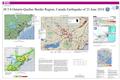 2010 Central Canada earthquake - USGS poster.pdf 5,400 × 3,600; 11.78 MB
-
 2014 Fort Tryon Park tour view of Inwood Lowlands.jpg 4,360 × 2,202; 2.06 MB
-

-
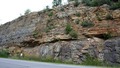
 Angular unconformity Shawangunk Martinsburg Otisville NY.jpg 1,544 × 1,028; 327 KB
-
 Annual report of the Regents (1900) (14756348746).jpg 3,456 × 2,160; 2.15 MB
-
 Annual report of the Regents - New York State Museum. (1902) (18745669893).jpg 4,712 × 1,162; 749 KB
-
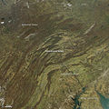 Appalachian Pennsylvania salient satfoto.jpg 720 × 720; 275 KB
-
 AwastingFalls Minnewaska State Park NY.jpg 960 × 1,280; 438 KB
-
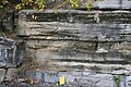
 Becraft Formation.jpg 1,200 × 499; 84 KB
-
 Bedrock in Saw Kill, Rock City, NY.jpg 2,460 × 2,220; 5.43 MB
-
 Beekmantown xbed.jpg 3,456 × 2,304; 2.45 MB
-
 Block of Fordham Gneiss - The American Museum journal (c1900-(1918)) (18133027776).jpg 1,700 × 1,542; 721 KB
-
 Columnar Jointing in the Palisades Sill.JPG 754 × 564; 114 KB
-
 Cross-section of the Helderberg Ridge, NY.png 585 × 237; 34 KB
-
-

-
 Helderbergescarpment.jpg 2,560 × 1,536; 846 KB
-
 Hornblende schist (Manhattan Island, New York State, USA) (41247413874).jpg 2,490 × 1,652; 3.72 MB
-
 Joints 1.jpg 3,456 × 2,304; 3.96 MB
-
 Lemonsqueezer.jpg 1,152 × 1,728; 546 KB
-
 Mudcracks in Silurian Limestone in New York state.jpg 2,048 × 1,536; 1.4 MB
-
 Myrmekite LyonMtn.gif 318 × 218; 43 KB
-
 New York Level III and Level IV ecoregions.pdf 7,200 × 5,550; 21.51 MB
-
 Oncolites.JPG 3,456 × 2,304; 1.52 MB
-

-
 Phacops-enrolled.jpg 414 × 372; 38 KB
-
 Potsdam Sandstone Unconformity.tif 3,456 × 1,944; 19.25 MB
-
 Potsdam sst 010607-5 100x xpl.tif 2,560 × 2,048; 15.01 MB
-
 PotsdamSandstone xbeds.jpg 3,456 × 2,304; 5.92 MB
-
 PSM V13 D678 New york harbor in preglacial times.jpg 1,630 × 1,090; 597 KB
-
 PSM V13 D679 Hudson river and the old littoral plain.jpg 1,658 × 995; 234 KB
-
 PSM V49 D172 Hillside washdown to the base plane of erosion.jpg 1,019 × 249; 36 KB
-
 RamapoFaultSystem.png 600 × 855; 822 KB
-
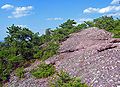 Schunemunk conglomerate and pine.jpg 2,433 × 1,755; 837 KB
-
 Trough xbeds.jpg 3,456 × 2,304; 2.82 MB
-
 USGS 2006 1237 Fig7b.png 1,713 × 709; 138 KB
-
 Xenolith Larchmont.jpg 1,520 × 2,272; 2.06 MB
-
 Zoophycos mcr3.JPG 2,304 × 3,456; 7.49 MB

.jpg)

_(14756348746).jpg)


)_(18133027776).jpg)


_(41247413874).jpg)


_1_(49130769916).jpg)


_(18745669893).jpg)